“Atmospheric River” Produces Little Run Off

December 16, 2016

img_4586

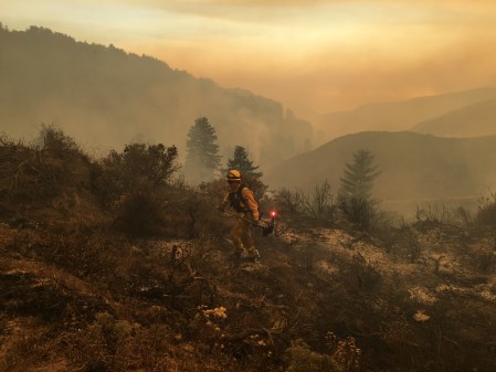
Once saturated, scorched slopes like these, can produce dangerous debris flows. It just has to rain hard enough and long enough.

The atmospheric river type storm that swept through the Santa Lucia Mountains yesterday produced close to the advertised 6 inches of rain at the wettest Coast Ridge spots, but produced relatively little run off and no serious debris flow problems.

While slides predictably closed Highway One on the South Coast (it will probably reopen later this afternoon), the larger streams pretty much shrugged the event off.

The Big Sur River peaked at over 1,000 cfs last night, but its channel can accommodate many times that much water without difficulty. For comparison, during the storms following the Marble Cone Fire, in January 1978, the Big Sur River reached a record 10,700 cfs.

The Nacimiento River, whose watershed did not burn, reached the highest flow of any Santa Lucia stream early this morning, with around 2,500 cfs. That is a relative trickle for a stream that has produced flows exceeding 50,000 cfs during extreme rain events. No water has, so far, even reached the bone dry San Antonio River gauge.


Soberanes Fire: Week Twelve

October 7, 2016

IMG_2919

As the twelfth, and hopefully final, week of the Soberanes Fire begins, 132,100 acres have burned and containment has reached 98%.

Some of the best information currently available on the state of the burned area is contained in the recently released Soberanes Fire Watershed Emergency Response Team (WERT) Report.

The first significant rain of the season may arrive during the coming week. Hopefully, it will be enough to put the fire definitively out, but not enough to set off damaging debris flows in denuded watersheds.

Update: The Soberanes Fire was declared 100% contained on Wednesday, October 12, 2016; almost a full 12 weeks after it began on July 22.


Soberanes Fire: Week Eleven

September 30, 2016

September 30, 2016

img_3805

View up Piney Creek at the fire’s eastern corner. Spotting over the line was still creating headaches there last week, but all is quite now.

As week eleven begins, the official numbers for the Soberanes Fire stand at 132,069 acres and 92% containment. Full containment is expected by noon on October 15, but could certainly come sooner, as only scattered hot spots and occasional interior flare ups remain.

There could be more of these today and tomorrow, as another wind event is expected this afternoon and evening, but the containment lines are unlikely to be challenged.


Soberanes Fire: Week Ten

September 23, 2016

Important caveats: Please note that the squares on the heat detection maps represent the expected margin of error, not the size of the area burned. In other words, the detection could have come from anywhere within the square. Also be aware that false detections do sometimes occur. An outlying or “over the line” heat detection is not, by itself, a confirmation that there is fire in the area indicated. In addition, the satellites do not detect heat everywhere that fire exists. Creeping, backing or smoldering fire is often not detected. Finally, the detections are only snapshots of moments in time. Flare ups that occur before or after a satellite pass may be entirely missed.

Also be aware that yellow squares disappear from the map after 6 days. These are not maps of the area burned since the fire began, just maps of where heat has been detected during the past week. Read the rest of this entry »


Soberanes Fire: Week Nine

September 19, 2016

Important caveats: Please note that the squares on the heat detection maps represent the expected margin of error, not the size of the area burned. In other words, the detection could have come from anywhere within the square. Also be aware that false detections do sometimes occur. An outlying or “over the line” heat detection is not, by itself, a confirmation that there is fire in the area indicated. In addition, the satellites do not detect heat everywhere that fire exists. Creeping, backing or smoldering fire is often not detected. Finally, the detections are only snapshots of moments in time. Flare ups that occur before or after a satellite pass may be entirely missed.

Also be aware that yellow squares disappear from the map after 6 days. These are not maps of the area burned since the fire began, just maps of where heat has been detected during the past week. Read the rest of this entry »


Soberanes Fire: Week Eight

September 9, 2016

For more recent updates, please see Soberanes Fire: Week Nine

Important caveats: Please note that the squares on the heat detection maps represent the expected margin of error, not the size of the area burned. In other words, the detection could have come from anywhere within the square. Also be aware that false detections do sometimes occur. An outlying or “over the line” heat detection is not, by itself, a confirmation that there is fire in the area indicated. In addition, the satellites do not detect heat everywhere that fire exists. Creeping, backing or smoldering fire is often not detected. Finally, the detections are only snapshots of moments in time. Flare ups that occur before or after a satellite pass may be entirely missed.

Also be aware that yellow squares disappear from the map after 6 days. These are not maps of the area burned since the fire began, just maps of where heat has been detected during the past week. Read the rest of this entry »


Soberanes Fire: Week Seven

September 2, 2016

Important caveats: Please note that the squares on the heat detection maps represent the expected margin of error, not the size of the area burned. In other words, the detection could have come from anywhere within the square. Also be aware that false detections do sometimes occur. An outlying or “over the line” heat detection is not, by itself, a confirmation that there is fire in the area indicated. In addition, the satellites do not detect heat everywhere that fire exists. Creeping, backing or smoldering fire is often not detected. Finally, the detections are only snapshots of moments in time. Flare ups that occur before or after a satellite pass may be entirely missed.

Also be aware that yellow squares disappear from the map after 6 days. These are not maps of the area burned since the fire began, just maps of where heat has been detected during the past week. Read the rest of this entry »


Soberanes Fire: Week Six

August 26, 2016

Important caveats: Please note that the squares on the heat detection maps represent the expected margin of error, not the size of the area burned. In other words, the detection could have come from anywhere within the square. Also be aware that false detections do sometimes occur. An outlying or “over the line” heat detection is not, by itself, a confirmation that there is fire in the area indicated. In addition, the satellites do not detect heat everywhere that fire exists. Creeping, backing or smoldering fire is often not detected. Finally, the detections are only snapshots of moments in time. Flare ups that occur before or after a satellite pass may be entirely missed.

Also be aware that yellow squares disappear from the map after 6 days. These are not maps of the area burned since the fire began, just maps of where heat has been detected during the past week. Read the rest of this entry »


Is a Sane Evacuation Policy Too Much to Ask For?

August 24, 2016

100_0508

Dealing with disaster is hard enough already. The rules shouldn’t make it harder.

The way we handle evacuations is broken. Current policy actually encourages people to ignore evacuation orders and has, during the Soberanes Fire, led to a wide variety of injustices and absurdities. Read the rest of this entry »


Soberanes Fire: Week Four

August 12, 2016

Important caveats: Please note that the squares on the heat detection maps represent the expected margin of error, not the size of the area burned. In other words, the detection could have come from anywhere within the square. Also be aware that false detections do sometimes occur. An outlying or “over the line” heat detection is not, by itself, a confirmation that there is fire in the area indicated. In addition, the satellites do not detect heat everywhere that fire exists. Creeping, backing or smoldering fire is often not detected. Finally, the detections are only snapshots of moments in time. Flare ups that occur before or after a satellite pass may be entirely missed.

Also be aware that yellow squares disappear from the map after 6 days. These are not maps of the area burned since the fire began, just maps of where heat has been detected during the past week. Read the rest of this entry »