Important caveats: Please note that the squares on the heat detection maps represent the expected margin of error, not the size of the area burned. In other words, the detection could have come from anywhere within the square. Also be aware that false detections do sometimes occur. An outlying or “over the line” heat detection is not, by itself, a confirmation that there is fire in the area indicated. In addition, the satellites do not detect heat everywhere that fire exists. Creeping, backing or smoldering fire is often not detected. Finally, the detections are only snapshots of moments in time. Flare ups that occur before or after a satellite pass may be entirely missed.
Also be aware that yellow squares disappear from the map after 6 days. These are not maps of the area burned since the fire began, just maps of where heat has been detected during the past week.
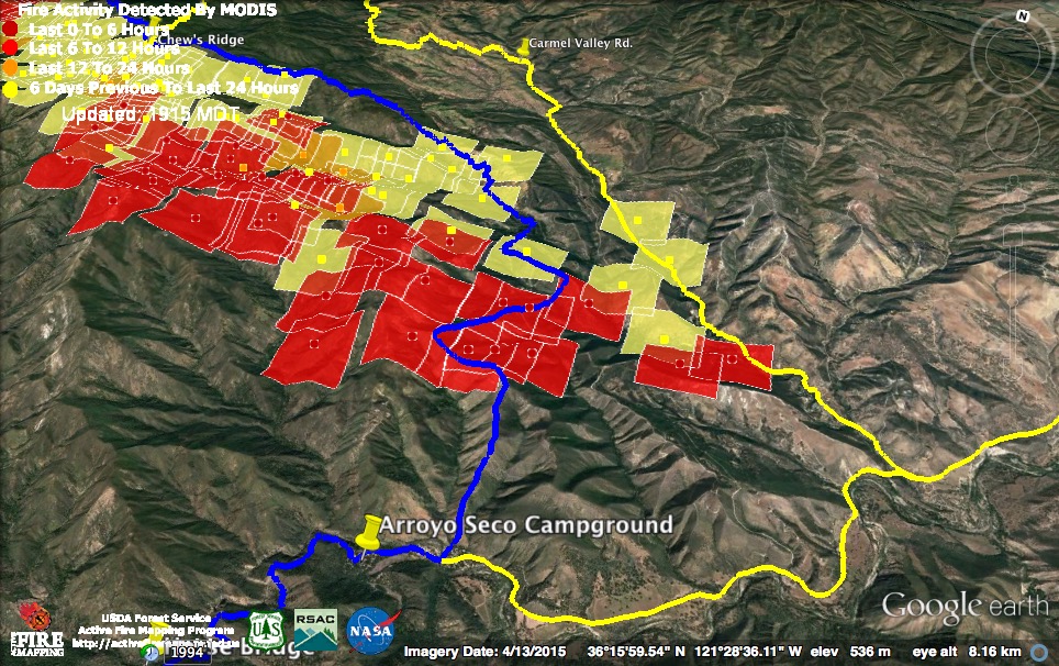
For more recent updates, please see Soberanes Fire: Week Ten
9-22-16 6:30 pm Update
The fire hadn’t really gotten cranking when the 11:00 am MODIS satellite passed over. It found heat in only one spot (the light red square) in the, probably inconsequential, slop over at the fire’s eastern edge. The 2:30 pm pass was a different story, though, finding a lot of active fire (the dark red squares) throughout the Church Creek drainage. The good news is that there was no sign of fire have progressed further toward the Tassjara Zen Center. No new heat detections from the slop over on top of Chews Ridge is also good news.
There has been no official word on the fate of the English Cabin or the buildings at the Church Ranch.
The wind is expected to ease off this evening, but the high humidity is dissipating as well. Relative humidity was already down to 18% at Tassajara this afternoon and the trend is expected to be toward hotter and drier conditions through the weekend.
Current official numbers: 125,344 acres; 71% contained; 57 homes and 11 outbuildings destroyed; 1 fatality; 7 injuries.
9-22-16 7:45 am Update

As feared, the wind blew the fire in Pine Valley through the Church Creek Divide and down Church Creek toward Tassajara. This is what the infrared scan found at about 9:00 pm last night. The leading edge of the fire at that time was just past the Church Ranch and moving onto the slopes between the creek and the Tassajara Rd.
Notice that the scan also found an active fire front still backing into Anastasia Canyon.
Click here to view this morning’s complete infrared map.
Two hours later, at around 11:00 pm, a MODIS satellite recorded these light red heat detections. They suggest further expansion on all sides of the initial run. The 3:00 am satellite, though, found heat in only one place (the dark red heat detection). Apparently, high humidity had begun to prevail over wind by that time.
In spite of the wind, this was the only area in which the fire made a run. The perimeter of the Soberanes Fire, as opposed to the Forest Service firing operation, did not expand.
9-21-16 9:00 pm Update

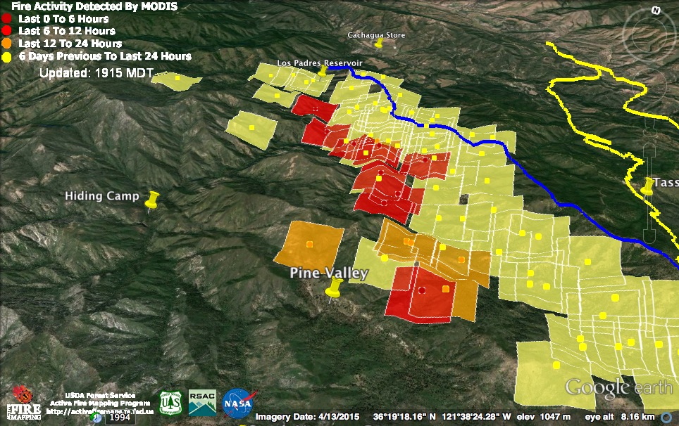
Heat detections acquired at around 12:30 pm and 2:00 pm today indicate that the fire in the Pine Valley area was already being blown to the southwest toward the Church Creek Divide and the Tassajara Creek watershed. Winds should continue to push it in that direction tonight and into tomorrow.
There were no new heat detections from the fire over the line near the top of Chews Ridge.
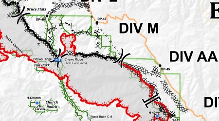
Today’s Operations Map indicates a proposed new dozer line, which is clearly intended to contain the Chews Ridge slop over. When fire slopped over in this area during the Basin Complex Fire it was allowed to burn out the entire area between the dozer lines and the “R-R-R” line on this map. This time, they apparently intend to stop it earlier, but at the cost of creating a new dozer line through designated Wilderness. In any case, this fire has shown little sign of life today.
9-21-16 9:30 am Update
As a result of “favorable overnight humidity recoveries,” the fire lost a lot of heat and impetus last night. So much so that the overnight MODIS satellites were unable to find any heat. This is very fortunate, considering the strength of the wind event expected to begin this afternoon.
This morning’s infrared map, based on data acquired around 10:00 pm last night, shows that the Forest Service firing operation has now reached the area previously burned by the Soberanes Fire from around Sulphur Springs, on the Carmel River, down to the Los Padres Reservoir, and in the Pine Valley area. As was indicated by MODIS yesterday, Pine Valley has burned. There is, as yet, no word on the status of the English Cabin.
As was also suggested by MODIS yesterday, the fire over the line on Chews Ridge has only grown a little, mainly creeping lower into the Anastasia Canyon drainage.
There is still no sign of fire getting established in the Tassajara drainage, but that could certainly change this afternoon or tonight, if wind pushes the fire in Pine Valley over the Church Creek Divide.
I’m not sure what the single heat detection along Church Creek signifies. It is right at the location of the Church Ranch, so perhaps they were doing some controlled burning around the buildings.
Current official numbers: 123,241 acres; 71% contained; 57 homes and 11 outbuildings destroyed; 1 fatality; 7 injuries.
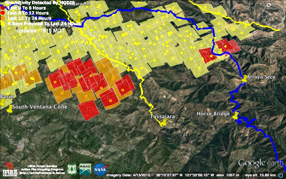
9-20-16 pm 7:00 pm Update

An overview of the fire zone. Dark red squares were acquired around 3:00 pm this afternoon; light red squares (which appeared in the last update) were acquired around 11:30 am this morning.
The most active burning this afternoon appears to have taken place along the Bruce Fork of the Carmel River, around Pine Valley, and in the “spot fire” near the top of Chews Ridge. With the Bruce Fork now burning, about the only unburned portion of the Carmel River watershed upstream of Los Padres Dam is the headwaters above Pine Valley. So much for weeks of effort to keep the fire west of the Carmel River.
There were no new heat detections at the western edge of the burn. This is unsurprising since the fire there has run up against territory burned weeks ago by the Soberanes Fire.
There were scattered heat detections at the eastern end, but none appear to represent expansion of the burn area. The satellite saw no sign of fire getting established in the Tassajara watershed, but there are rumors this evening of fire backing into the Church Creek drainage (a tributary of Tassajara Creek).
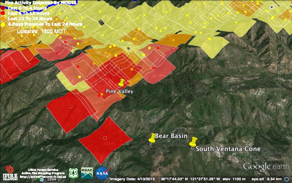
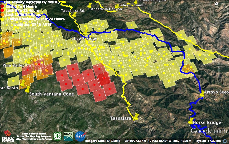
Pine Valley was looking pretty warm to the MODIS satellite this afternoon and there is even a heat detection as far west as Bear Basin Creek. There’s a rumor that the area around the English Cabin in Pine Valley was backfired today. I have no idea whether that’s actually true.
If fire has actually moved as far west as indicated by these heat detections, it is already bumping up against the area previously burned by the Soberanes Fire, and further expansion to the west will be limited. What remains unburned, is everything to the left. Exactly the direction that the heavy northwest winds forecast to begin tomorrow afternoon will tend to blow the fire. What lies in that direction is the Tassajara Creek watershed. Let’s hope the fire lies down before that happens.
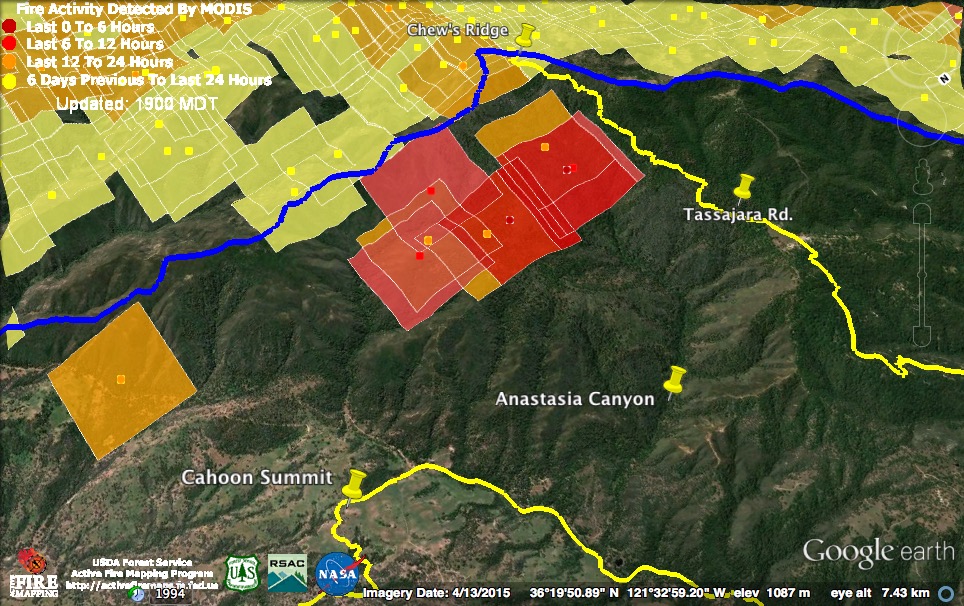
The fire on the wrong side of the line was still hot this afternoon, but there is no indication of significant expansion. If anything, it may have moved slightly deeper into Anastasia Canyon. There is a rumor that firefighters are preparing to backfire from the Tassajara Rd. to protect the Nason’s place (which is just below the “Rd.” in “Tassjara Rd.”).
There is some urgency in getting the fire knocked down as much as possible before tomorrow afternoon, as powerful northwest winds are expected. A red flag fire warning has been declared for the fire area from 3:00 pm Wednesday to 9:00 pm Thursday, due to this wind.
Here is what the National Weather Service has to say about it:
A DRY COLD FRONT WILL REACH MONTEREY COUNTY STARTING WEDNESDAY AFTERNOON. TYPICAL AFTERNOON ONSHORE WINDS WILL START TO BE ENHANCED AS THE FRONT APPROACHES. THE STRONGEST WINDS WILL OCCUR OVERNIGHT WEDNESDAY INTO THURSDAY. THE STRONGEST WINDS WILL BE OVER THE RIDGES ABOVE 3000 FEET NEAR CHEWS RIDGE AND TASSAJARA ROAD WHERE GUSTS FROM 35-40 MPH WILL BE COMMON BY THURSDAY MORNING. STRONG AND GUSTY NORTHERLY RIDGE TOP WINDS WILL CONTINUE THROUGH THE DAY THURSDAY BEFORE GRADUALLY DIMINISHING THURSDAY EVENING. EVEN THOUGH TEMPERATURES WILL BE COOL WITH SLIGHTLY HIGHER HUMIDITY ON THURSDAY…WINDS OF THIS MAGNITUDE WILL CREATE CRITICAL FIRE WEATHER CONDITIONS.
9-20-16 3:45 pm Update

There are two large columns visible over the fire this afternoon and the 11:30 am MODIS satellite suggests that one of them is coming from the “spot fire” near Anastasia Canyon. The dark red squares are from the 11:30 am pass; the light red squares are from the 3:30 am pass (and were included on this morning’s maps).
The Forest Service finally issued today’s complete report and it says the following about this spot fire:
An unanticipated wind event materialized yesterday. Strong wind shifts to the southwest produced gusts of 30-40 mph, resulting in embers being carried across the control line just north of Chews Ridge. Last night an infrared mapping flight showed the spot fire to be approximately 250-300 acres in size with little growth throughout the night. Firefighters who were pre-staged in the area were able to quickly attack the spot fire. Crews will be continuously working throughout the day to achieve containment in conjunction with aviation resources.
By “little growth overnight” I assume they mean after the big runs everyone was seeing and photographing last night around midnight were finished. There is still no word on whether they are working to contain it in place or intend to let it burn out to indirect lines.
There are rumors that this fire is already contained or nearly contained but, as of 11:30 this morning, it was still putting out a lot of heat, a lot of smoke has continued to rise throughout the afternoon, the new evacuation orders have not been lifted, and the Forest Service, which is usually pretty quick to announce good news, has not announced containment.
When fire jumped the lines in this location during the Basin Complex Fire, it resulted in a needless and prolonged mandatory evacuation of most of Cachagua. Fortunately, that has not happened this time.

The other big column visible this afternoon is almost certainly rising from the Pine Valley area. Some of these heat detections may be erroneous, but probably not all of them.
Current official numbers: 121,050 acres; 71% contained; 57 homes and 11 outbuildings destroyed; 1 fatality; 7 injuries.
9-20-16 9:30 am Update
The Forest Service has finally issued an update. Here is their statement on last night’s Chews Ridge slop over:
Unfavorable weather conditions and strong NSW winds, carried embers across the control line near Chews Ridge and into heavy fuels. This wind event produced a spot fire on the east side of the dozer/containment line resulting in a new evacuation order. In addition, two evacuation warnings were issued.
Notice that they say nothing about how efforts to contain the slop over are going or what the strategy for containing it is (going direct? bringing it out to a new set of indirect lines?). This is the information that would be most helpful to people with property in the area.
Here is their full statement on current evacuation orders and warnings:
A new evacuation order was issued for the east side of Tassajara Road from Chews Ridge to Bruce Ranch. Bruce Ranch east along Anastasia Canyon to Carmel Valley Road. Carmel Valley Road south from Anastasia Canyon to Tash Ranch.
New Evacuation Warnings were issued from:
North of Carmel Valley Road from Hastings Preserve, from Cahoon Ranch east to Tash Ranch.
The Evacuation Order for Tassajara Road south of Chews Ridge remains in effect.
The Evacuation warning for the east side of the fire near Arroyo Seco, southwest of East Carmel Valley Road starting at the intersection of East Carmel Valley Road and Piney Creek Road, extending east to the Arroyo Seco Road remains in effect. As well as the warning for the Arroyo Seco Road from East Carmel Valley Road extending west past the Arroyo Seco Campground.
Firing operations have been suspended “until weather, fuels and topography are back in alignment.” Also, presumably, until the fire from the previous firing operations is brought back under control.
9-20-16 7:30 am Update
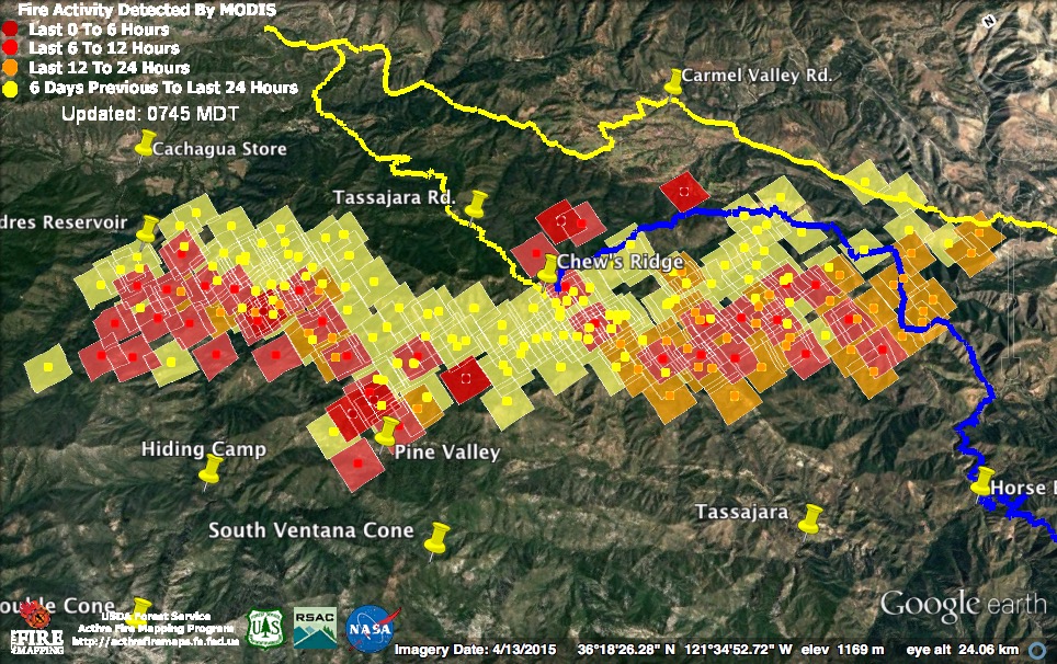
The MODIS satellites found no evidence of yesterday’s big flare up, near the eastern end of the firing operation, expanding further last night (and no further evidence of heat on the wrong side of the containment line in that area), but they did find the new slop over, closer to the top of Chews Ridge, that resulted in new evacuation orders last night. They also found fire moving into, if not across, Pine Valley (let’s hope the English Cabin is OK), and a large flare up moving across the Carmel River between Carmel River Camp and the Los Padres Reservoir, to reach areas previously burned. There is still no evidence of fire establishing itself in the Tassajara Creek watershed.
Once again, there was no heat detected from the actual Soberanes Fire, only from the Chews Ridge firing operations.
The light red squares were acquired around 11:30 pm last night; the dark red squares around 3:30 am this morning. I apologize for having omitted the containment line between the Chews Ridge Summit and the Los Padres Reservoir.

A close-up of last night’s Chews Ridge slop over. If the 3:30 am heat detection on the far left is to be believed, there is fire over the line in both the Arroyo Seco and Carmel River watersheds. Fire also slopped over in this area during the Basin Complex Fire.
In spite of new evacuation orders being issued in the middle of the night last night, the Forest Service has not issued any new information on the fire in more than 19 hours now. Information, once again, has dried up just when people want, and need, it the most. Apparently the Forest Service doesn’t like to admit when fire spots over lines, and delays updates hoping that, if they wait a while, they’ll get it put out and be able to report once again that all fire is within containment lines.

This morning’s infrared map, based on data acquired around 11:30 pm last night, shows the beginning of the slop over.
Special Midnight Update
There is fire somewhere on the wrong side of the line on Chews Ridge. An evacuation order has apparently been issued for the east side of Tassajara Rd. high on the ridge and an evacuation warning has apparently been issued for the Carmel Valley Rd. from Hastings up to Cahoon Summit. There are reports of fire in, or near, Anastasia Canyon (which also burned in a slop over during the Basin Complex Fire). More fire crews are being called in.
9-19-16 7:15 pm Update
It’s easy to explain what the Soberanes Fire has done since my last update (which was five days ago). It’s done nothing.
There are still hot spots visible to the infrared scanning planes, but there have been no new MODIS heat detections and the fire has not expanded its perimeter at all.
The firing operations on Chews Ridge are another story…

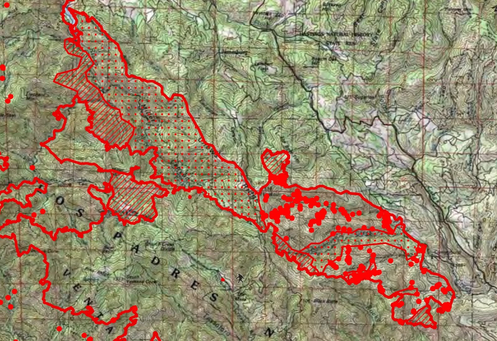
The red squares on the map were acquired at around 12:30 pm and 2:00 pm today. The blue line is the primary containment line (there are multiple contingency lines in the area where fire appears to be spilling over today). The yellow lines are the Tassajara, Carmel Valley and Arroyo Seco roads.
So far, the firing operations have clearly succeeded in creating a wide burned zone along the containment lines, but the Forest Service goal of burning out only a “perimeter” and not igniting “all the unburned vegetation inside the Ventana Wilderness” seems to be going less well. The firing operation has spread over thousands of acres of Wilderness, crossing the Miller Fork of the Carmel River and climbing, or spotting, to the ridge on the other side (overlooking Pine Valley). It has also brought fire close to Tassajara.
This map shows the approximate location of the fire on the ridge between Pine Valley and the Miller Fork. The Forest Service says that they are still working “to prevent fire from establishing east of the Carmel River,” which is kind of funny considering that their backfire has now burned nearly everything on the east side of the Carmel River that had not already burned.
Here’s the southeastern end of the firing operations. The heat detections closest to the Carmel Valley Rd. are very low confidence and are likely erroneous. The others are probably inside the various contingency lines that exist in the area. This is where the huge smoke column visible from practically everywhere today was coming from.

Here’s the location of today’s burning relative to the Tassajara Zen Center. There is no indication that the fire has established itself in the Tassajara Creek watershed. Let’s hope firefighters are able to prevent that from happening.
This evening’s official numbers: 117,656 acres; 67% contained.
For earlier updates, please see Soberanes Fire: Week Eight

Glad to see you back. Let’s hope those MODIS sightings are erroneous, but they did have a 5 acre slop over that they were able to contain last night. Did bring in a strike team from Santa Cruz and Santa Clara around 5 pm, though. Makes one wonder…
As of 7:45 am on Tuesday, 9/20/16, I am getting lots of reports of engines roaring in (at least 3, maybe more) with lights and sirens blaring.
Hi Keith. Really good info. Thanks.
Second map down from the top. Is the map inverted? It shows Carmel Valley Rd. west of Tassajara rd. Is the view from the north? The other map show familiar presentation.
It’s a view from the north. Since the fire is burning on a north slope, it’s the only way to get a good view of the fire along with the topography.
I’m trying to find where the USFS posted the above update, and haven’t located it yet. Can you share?
It’s on Inciweb.
Thanks for this information Keith. As you mentioned awhile back they took a huge risk with the firing operations they implemented. They have also done a very poor, inept job at communicating with local communities about their plans. Now it has suddenly gotten worse in part because of those actions…let’s all pray it doesn’t get even more out of hand and affect more folks
… Now just under 190 square miles burned so far…. (:>((
The next few days will be interesting, to say the least. I am above 3,000 ft so will be watching with much interest.
The way this incident team went into CYA mode over the Piney Canyon line jump was pretty disheartening. Inaccurate info spread about the fire location, radio silence, copters scrambling for retardant that wasn’t available, local FS officials not informed. I cringed when they kept lighting Chews even with strong southern gusts coming up, but I don’t really even begrudge the line jump. They got caught going too big, too fast, though—probably to get crews home and costs down—and responded poorly. That sews distrust and anxiety on the ground.
“The perimeter of the Soberanes Fire, as opposed to the Forest Service firing operation, did not expand.”
Quite a sentence, XT:)
A few numbers might add even a bit more force to the quote Chris L highlighted.
As of 9/14, just before the Chews Ridge operation began, the fire acreage total was about 107,500, with 70,000 in the national forest. (I’m rounding to the nearest 500.) This morning the numbers are 125,500 total and 88,000 LPNF. Since the original perimeter hasn’t moved, that means 18,000 acres (a bit over 28 square miles) are linked to the firing operation and subsequent expansion. That less than 10% of the total but more than 20% of the national forest burn.
While I understand that’s not what the planners expected, the net result is sure seems a high price for mitigating what appeared, even before the firing operation, like a limited risk.
OTOH, and I am by no means certain of this, but isn’t it possible the burn out operation allowed them the confidence they needed to be able to save the English Cabin, the Church Ranch and The Caves, by backfiring, and Tassajara, when the time comes, knowing that if any of the back burn operations got away from them, it wouldn’t take out the communities they were trying to protect? I really don’t know, but am willing to look at that possibility. bigsurkate
That’s possibly an accurate assessment of their strategy, but why are we having to guess? The approach of this team was to take big risks burning out Chews Ridge, with little info provided as to the immediate need for it other than a general burnout of the big box. Then went that went sideways in Piney, they clammed up.
I agree something like that might have been a consideration. I can certainly imagine the planners working though the scenarios and seeing that IF the Soberanes fire got moving again in the north (even though it hadn’t in a while and the first BAER products were already out), then having a buffer would position them to take more direct action … as well, of course, for providing additional protection outside the lines. Firefighting is an act of balancing risks. But behind that is the judgement that working that IF is worth the the countervailing risk: that the backfire would go way farther than expected. Which it did.
I would hope when all this is over and the world can be a bit more dispassionate, that there can be a measured revisit of how, in the California coast ranges, to best balance the risks of backfires, buffers, and living with a smoldering fire without formal containment. Maybe revisit at the role of prescribed burns and non-emergency management too, since I sometimes wonder if our reluctance to do any of that contributed to overly bold action during the emergency.
I would also hope that that there is a revisit of what I suspect is an unstated and perhaps even unrealized assumption that enters into the risk evaluations: that fire is a wholly natural part of the coast range landscape and thus, in the wilderness, is a low-consequence event. It’s no big deal to let the wilds burn if homes or other human assets are not affected. To some extent that’s true. Nature is resilient. But the landscape takes time to recover and we’ve now has four major fire events in this area in 40 years. In some cases, such as with the Ponderosa pine forest, it may never recover to an earlier state. Recreational use of the wilderness is impacted. And is the Carmel River hydrology going to be affected once again?
Via discussions with engine crews and radio chatter, plans are being made to burn from Tassajara Road toward Cahoon Spring as well as from the Nason/Chews break toward Tassajara Road. Very high risk burning through areas of dead trees with a high chance of sending things deep into Anastasia Canyon or breaching into Kincannon.
Yet I see briefing videos claiming “the fire didn’t move at all” last night and warning mostly of smoke nuisance for people in Arroyo Seco from fire “out there”. This team is simply either unaware or trying to minimize the seriousness of the Piney breach and reaching for the only tool in their toolbox, more fire.
Maybe they did, maybe they didn’t have a sound theoretical basis for burning so much so fast. But they didn’t communicate it, it went wrong, and they are not really changing course.