Soberanes Fire: Week Eleven

September 30, 2016

September 30, 2016

img_3805

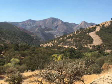
View up Piney Creek at the fire’s eastern corner. Spotting over the line was still creating headaches there last week, but all is quite now.

As week eleven begins, the official numbers for the Soberanes Fire stand at 132,069 acres and 92% containment. Full containment is expected by noon on October 15, but could certainly come sooner, as only scattered hot spots and occasional interior flare ups remain.

There could be more of these today and tomorrow, as another wind event is expected this afternoon and evening, but the containment lines are unlikely to be challenged.


Soberanes Fire: Week Ten

September 23, 2016

Important caveats: Please note that the squares on the heat detection maps represent the expected margin of error, not the size of the area burned. In other words, the detection could have come from anywhere within the square. Also be aware that false detections do sometimes occur. An outlying or “over the line” heat detection is not, by itself, a confirmation that there is fire in the area indicated. In addition, the satellites do not detect heat everywhere that fire exists. Creeping, backing or smoldering fire is often not detected. Finally, the detections are only snapshots of moments in time. Flare ups that occur before or after a satellite pass may be entirely missed.

Also be aware that yellow squares disappear from the map after 6 days. These are not maps of the area burned since the fire began, just maps of where heat has been detected during the past week. Read the rest of this entry »


Soberanes Fire: Week Nine

September 19, 2016

Important caveats: Please note that the squares on the heat detection maps represent the expected margin of error, not the size of the area burned. In other words, the detection could have come from anywhere within the square. Also be aware that false detections do sometimes occur. An outlying or “over the line” heat detection is not, by itself, a confirmation that there is fire in the area indicated. In addition, the satellites do not detect heat everywhere that fire exists. Creeping, backing or smoldering fire is often not detected. Finally, the detections are only snapshots of moments in time. Flare ups that occur before or after a satellite pass may be entirely missed.

Also be aware that yellow squares disappear from the map after 6 days. These are not maps of the area burned since the fire began, just maps of where heat has been detected during the past week. Read the rest of this entry »


Soberanes Fire: Week Eight

September 9, 2016

For more recent updates, please see Soberanes Fire: Week Nine

Important caveats: Please note that the squares on the heat detection maps represent the expected margin of error, not the size of the area burned. In other words, the detection could have come from anywhere within the square. Also be aware that false detections do sometimes occur. An outlying or “over the line” heat detection is not, by itself, a confirmation that there is fire in the area indicated. In addition, the satellites do not detect heat everywhere that fire exists. Creeping, backing or smoldering fire is often not detected. Finally, the detections are only snapshots of moments in time. Flare ups that occur before or after a satellite pass may be entirely missed.

Also be aware that yellow squares disappear from the map after 6 days. These are not maps of the area burned since the fire began, just maps of where heat has been detected during the past week. Read the rest of this entry »


Soberanes Fire: Week Seven

September 2, 2016

Important caveats: Please note that the squares on the heat detection maps represent the expected margin of error, not the size of the area burned. In other words, the detection could have come from anywhere within the square. Also be aware that false detections do sometimes occur. An outlying or “over the line” heat detection is not, by itself, a confirmation that there is fire in the area indicated. In addition, the satellites do not detect heat everywhere that fire exists. Creeping, backing or smoldering fire is often not detected. Finally, the detections are only snapshots of moments in time. Flare ups that occur before or after a satellite pass may be entirely missed.

Also be aware that yellow squares disappear from the map after 6 days. These are not maps of the area burned since the fire began, just maps of where heat has been detected during the past week. Read the rest of this entry »