Carmel River Reaches Minor Flood Stage

January 11, 2017

img_4810

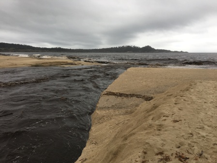
About 10 times this much water is now flowing across the sandbar at the Carmel River mouth.

The Carmel River peaked at 9.1 feet early this morning at Rosie’s Bridge in the Carmel Valley Village. That’s a flow of more than 7,000 cubic feet per second – and the largest flow the Carmel River has seen since 1998. 9 feet at Rosie’s Bridge is considered “minor flood stage” – although some flooding did occur earlier this week with the river below that level.

Runoff from lower tributaries has increased the size of the peak as it has travelled down Carmel Valley and 10,100 cfs are now passing the “Near Carmel” gauge near the river mouth. Further upstream, at Rosie’s Bridge, the river has already dropped to 7.26 feet (4,450 cfs).

Contrary to speculation on social media, the removal of the San Clemente Dam is not causing higher flows in Carmel Valley. The dam had been silted in, and having no impact on river flows, for decades before it was demolished.

What is of concern, are reports that the river has scoured away the carefully constructed “step pools” in its bypass channel at the former dam site and is incising that channel more deeply, leading to bank collapse and the loss of trees in the riparian zone upstream. It will be interesting to see what the new channel looks like, and how accommodating it will be for fish, once the water goes down.

8:30 am Update: The peak flows have now moved out to sea and all parts of the river are quickly receding. Flow at the mouth is now under 9,000 cfs.


Big Sur River Over Flood Stage for the Third Time in a Week

January 10, 2017

img172

Waterfall in the upper Big Sur drainage: You have to wonder what places like this look like right now…

The Big Sur River has done it again. As of 7:30, it is back over flood stage at 10.31 feet (4,620 cfs). Still a ways to go to match Sunday’s peak of 11.80 feet (6,820 cfs).

7:45 pm Update: Now 10.54 feet (4,950 cfs).

8:15 pm Update: Now 10.82 feet (5,360 cfs).

8:30 pm Update: Now 11.17 feet (5,890 cfs). Flow just increased by 530 cfs in only 15 minutes.

8:45 pm Update: Now 11.30 feet (6,080 cfs).

9:00 pm Update: Now 11.34 feet (6,140 cfs).

9:15 pm Update: Now 11.29 feet (6,070 cfs). Looks like we may have found the peak.

Also at 9:15, the National Weather Service placed a Severe Flash Flood Warning on the Soberanes Fire Burn area, due to heavy rain. They say they expect the Big Sur River to continue to rise.

Radar, in the other hand, indicates that rain over the Big Sur watershed is easing.

9:45 pm Update: Looks like the decline was just a hiccough. The Big Sur River is now at 11.44 feet (6,290 cfs). The NWS was right.

10:15 pm Update: Now 11.73 feet (6,720 cfs) – only 80 cfs below Sunday’s peak.

10:30 pm Update: Now 11.76 (6,760 cfs) – only 40 cfs below Sunday’s peak.

11:00 pm Update: The Big Sur River is now at 12.01 feet (7,150 cfs) – the second highest level ever measured on this stream. The greatest was 14,30 feet (10,700 cfs), in 1978. That record won’t likely be challenged tonight.

11:15 pm Update: Now 12.13 feet (7,330 cfs).

11:30 pm Update: Now 12.34 feet (7,650 cfs) – another quick rise.

11:45 pm Update: Now 12.25 feet (7,510 cfs). Another hiccough, or has the peak finally passed?

Midnight Update: Now 12.20 feet (7,430 cfs). Looks like the peak has really passed this time.

The main concern now is how high the Carmel River will go. It is still rising at the Los Padres Dam and is already higher there than it got on Sunday.

7:00 am Update: It looks like the Carmel River peaked at around 9.1 feet (just over flood stage) at Rosie’s Bridge in the early morning hours. That’s a bit over 7,000 cfs. The peak is now near the river mouth, where it has swollen to over 10,000 cfs – thanks to runoff from Garzas Creek and other lower tributaries.


Big Sur River Back Above Flood Stage

January 8, 2017

DSC05199

Big Sur Rain

Shortly before 3:00 pm this afternoon, the Big Sur River pushed its gauge above the 10 foot level that marks the official flood stage. The gauge was at 10.04 feet by 3:00, or 4,250 cubic feet per second. The river reached a peak flow of 4,950 cfs last Wednesday (10.54 feet).

Heavy rain is still falling over the Big Sur watershed at this time, but should begin decreasing soon as the storm moves off to the south. The watershed is small, so the river won’t keep rising for long, once the rain relents. Serious flooding is unlikely to occur until the gauge height exceeds 11 feet.

3:30 pm Update: River now at 5,250 cfs (Gauge height 10.75). That’s an increase of 1,000 cfs in half an hour.

4:00 pm Update: River now at 6,020 cfs (11.26 feet). Still rising quickly, though not as quickly. This is the largest flow the Big Sur River has seen since 6,590 cfs was recorded in February, 1998. Radar suggests heavy rain is still falling in the Big Sur watershed.

4:45 pm Update: River now at 6,420 cfs (11.53 feet). Rain may be easing some.

5:00 pm Update: Latest reading is 6,620 cfs (11.66 feet). This exceeds the 1998 flow and is the third highest flow ever recorded on the Big Sur River (after 1978 and 1995).

5:15 pm Update: Now the second largest flow ever recorded on the Big Sur River at 6,700 cfs (11.72 feet). With rain beginning to recede, there’s not much chance of it matching the 1978 flow of 10,700 cfs, I’m glad to say. Flows have been recorded since 1950.

5:30 pm Update: Still inching upward. Now 6,790 cfs (11.78 feet).

5:45 pm Update: 6,820 cfs (11.80 feet). How high will it go?

6:00 pm Update: Still 6,820 cfs at 6:00 pm. Have we finally found the peak?

6:15 pm Update: Yes! The river is now receding. 6,790 cfs (11.78 feet) at 6:15.


Big Sur River Above Flood Stage

January 4, 2017

img_4799

Heavy overnight rain falling on the Soberanes Fire burn scar has pushed the Big Sur River Gauge over the 10 foot level that is considered flood stage. The current level (at 6:00 am) is 10.48 feet. This translates to a flow of 4,860 cubic feet per second; essentially matching the 4,900 cfs peak flow of 2012 (which did not result in serious flood damage). The highest flow recorded at the Big Sur River Gauge, following the Marble Cone Fire in 1978, was 10,700 cfs.

The Big Sur River, with its smaller watershed, reacts to rain more quickly than the larger coastal streams. The Carmel River at Rosie’s Bridge is at 1,170 cfs and rising (peak flow there was 16,000 cfs in 1995).

The Arroyo Seco River Gauge is still only showing 161 cfs, but with some portions of its watershed receiving over 7 inches of overnight rain, the water will be rising quickly this morning.

The parched San Antonio River, which only began flowing past the gauge site on December 31, has only risen to 37 cfs… so far.

The Nacimiento River is at 4,350 cfs, an inconsequential amount for a stream that sometimes produces flows in excess of 50,000 cfs.

7:00 am Update: The Big Sur River is now above its 2012 peak; at 4,950 cfs (10.54 feet). The Arroyo Seco is at 1,140 cfs.

7:30 am Update: The Big Sur River has begun to drop. It’s currently at 4,720 cfs (10.38 feet). The Carmel River is up to 1,790 cfs. The Arroyo Seco is up to 1,990 cfs. The Nacimiento is up to 5,540 cfs.

9:30 am Update: The Big Sur River, at 9.95 feet (4,130 cfs), is no longer above flood stage. The Carmel River is at 2,630 cfs. The Arroyo Seco River has jumped to 7,560 cfs. The San Antonio River is barely changed at 39 cfs; and the Nacimiento now has the greatest flow, with 7,800 cfs. Some of the wettest spots along the Coast Ridge have received over 10 inches of rain since this storm began.

1:30 pm Update: The peaks have now passed on the local streams. It looks like the Nacimiento and Arroyo Seco rivers got up into the neighborhood of 12,000 cfs, or so, and the Carmel to around 2,700 cfs. The San Antonio, which must be dumping a lot of water into its bone dry aquifer, is still only pushing 41 cfs past the gauge.

With an even wetter storm forecast for this weekend, it would be prudent for those who live near streams to prepare for debris flows and the possibility of record, or near record, water levels.