March 8, 2013

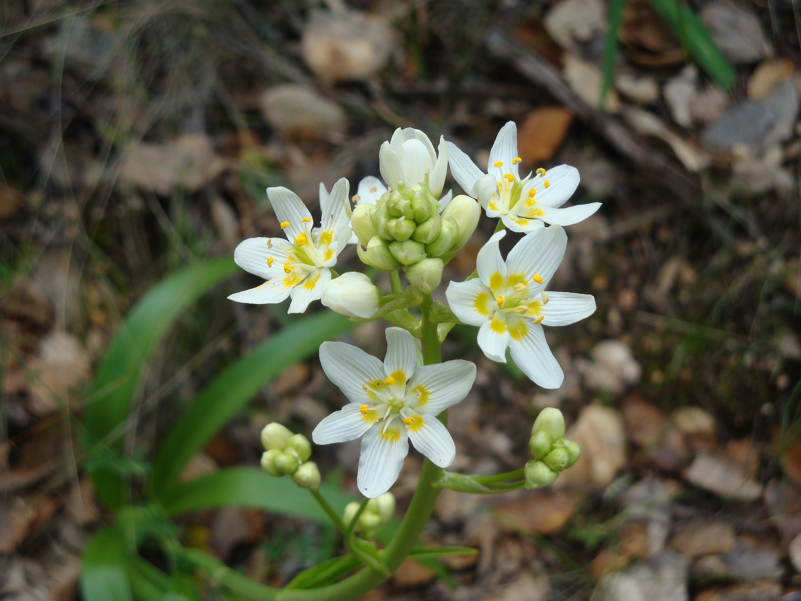
Star Lily (Zigadenus Toxicoscordion fremontii), AKA Fremont’s Death Camus or Star Zigadene, at Garland Regional Park
It’s been a strange season so far, with heavy rain in the fall, followed by the driest January/February on record. But one flower that seems to be thriving in these odd conditions is the star lily – now abundantly blooming pretty much anywhere you look in Monterey County. Read the rest of this entry »
 2 Comments |
  Big Sur, Plants, Santa Lucias, Wildflowers | Tagged: fremontii, star zigadene, toxicoscordion, zigadenus |
  Permalink
 Posted by xasauan
December 3, 2012

Clearing storm: Summit of Cone Peak; just south of Mining Ridge
Storms generally weaken as they move south, dropping more rain north of the Golden Gate and in the Santa Cruz Mountains than in Monterey County. But Big Sur’s Coast Ridge is an exception. Rising directly from the ocean to over 5,000 feet at Cone Peak, the Coast Ridge forms a high wall, lifting clouds and wringing an incredible amount of moisture out of passing storms. Read the rest of this entry »
4 Comments | Big Sur, Fire, Flood & Apocalypse, Santa Lucias | Tagged: Big Creek, Coast Ridge, Cone Peak, Mining Ridge | Permalink
Posted by xasauan
December 2, 2012

The March, 2011 Rocky Creek slide still under repair
At 9:30 tonight Caltrans shut Highway One down from “4 miles south of Big Sur” (apparently between Deetjen’s and the Coast Gallery) all the way to Ragged Point in San Luis Obispo County “due to flooding.” That’s about 50 miles of highway closed and there is “no estimated time to reopen.” We don’t know where the “flood” is, or if this is just shorthand for lots of rocks and slides, but this is probably a good night to stay off the roads in the areas hardest hit by today’s storm.
10:45pm Update: Big Sur Kate is reporting that the cause of the closure is a slide at Rain Rocks (between Lucia and Limekiln Creek).
8:00am December 3 Update: The Highway appears to have been reopened.
1 Comment | Big Sur, Fire, Flood & Apocalypse, Santa Lucias | Permalink
Posted by xasauan
December 2, 2012
As of 2:00pm the Big Sur River was at 10.51 feet and climbing. 10 feet is the official flood stage, although past experience indicates that serious flooding does not actually begin until the river gets higher. Flow is currently at 4,900 cfs and climbing. This is a couple hundred cfs more than the river’s peak during Big Sur’s last flood scare, in March 2011. View the Big Sur River gauge here.
2:30pm Update: It appears that peak flow has now passed. Latest readings are 10.47 feet and 4,850 cfs. The rain is tapering off rapidly over the Santa Lucias, so the river will probably start dropping quickly.
10:00pm Update: Nothing to do with the Big Sur River, obviously, but at 9:30 tonight Cal Trans shut Highway One down from 4 miles south of Big Sur all the way to Ragged Point in San Luis Obispo County “due to flooding.” Don’t know where the “flood” is, or if this is just shorthand for lots of rocks and slides. The Big Sur River, meanwhile, is all the way back down to 1,270 cfs. The Arroyo Seco River takes the prize for the day’s highest peak flow with around 14,000 cfs (an amount it can easily accommodate).
Leave a Comment » | Big Sur, Fire, Flood & Apocalypse, Santa Lucias | Permalink
Posted by xasauan
November 30, 2012

Lifting Clouds: 2:30pm November 30, 2012; as at least 9 solid hours of rain finally ends
It’s been awhile … a long while … since we’ve had as many hours of continuous rain as we had today. It’s early in the season, though, with the streams low and the watersheds still pretty dry, so it hasn’t created as much havoc as it might during wetter times. Read the rest of this entry »
1 Comment | Big Sur, Carmel River, Santa Lucias | Permalink
Posted by xasauan
November 13, 2012
9 Comments | Big Sur, On Foot, Plants, Santa Lucias | Tagged: black oak, Bottcher's Gap, Canyon Oak, Devil's Peak, Madrone, Mt. Carmel, Pico Blanco, Pine Creek, Ponciano Ridge, Ponderosa Pine, Skinner Ridge, Ventana Wilderness | Permalink
Posted by xasauan
November 3, 2012

As viewed from the Coast Ridge: The South Face of the Double Cone, with Kandlbinder Peak (AKA Pk. 4653) on the left, and a bit of The Window visible as a notch to the right of Kandlbinder
It was fall, 1974. I’d just turned 15 and, while I’d seen a lot of the Santa Lucia backcountry, I’d never been to The Window. Read the rest of this entry »
7 Comments | Big Sur, On Foot, Santa Lucias | Tagged: Big Sur River, Bottcher's Gap, Fox Camp, Happy Forks, Jackson Creek, Kandlbinder Peak, Pine Ridge Trail, The Window, Ventana Camp, Ventana Creek, Ventana Double Cone | Permalink
Posted by xasauan
October 16, 2012
When the fogs of summer drift away …

Morning on the coast Read the rest of this entry »
3 Comments | Big Sur, Cycling, Santa Lucias | Tagged: Big Sur Coast, Bixby, El Penon, Monterey Bay Marine Sanctuary, Palo Colorado, Sailing, Sid Ormsbee, The Window | Permalink
Posted by xasauan
September 29, 2012
Back in February we joined a Ventana Wilderness Alliance trail crew to work on the Little Sur Trail along the South Fork Little Sur. Today, in honor of National Public Lands Day, we returned with the VWA to work the other end of the Little Sur Trail, on the climb from the North Fork Little Sur to Launtz Ridge. Those with unnaturally good memories may recall that we posted some photos from a walk along this badly deteriorated trail back in November, 2010.

The crew gathers at the Pico Blanco Boy Scout Camp Read the rest of this entry »
3 Comments | Big Sur, On Foot, Santa Lucias | Permalink
Posted by xasauan