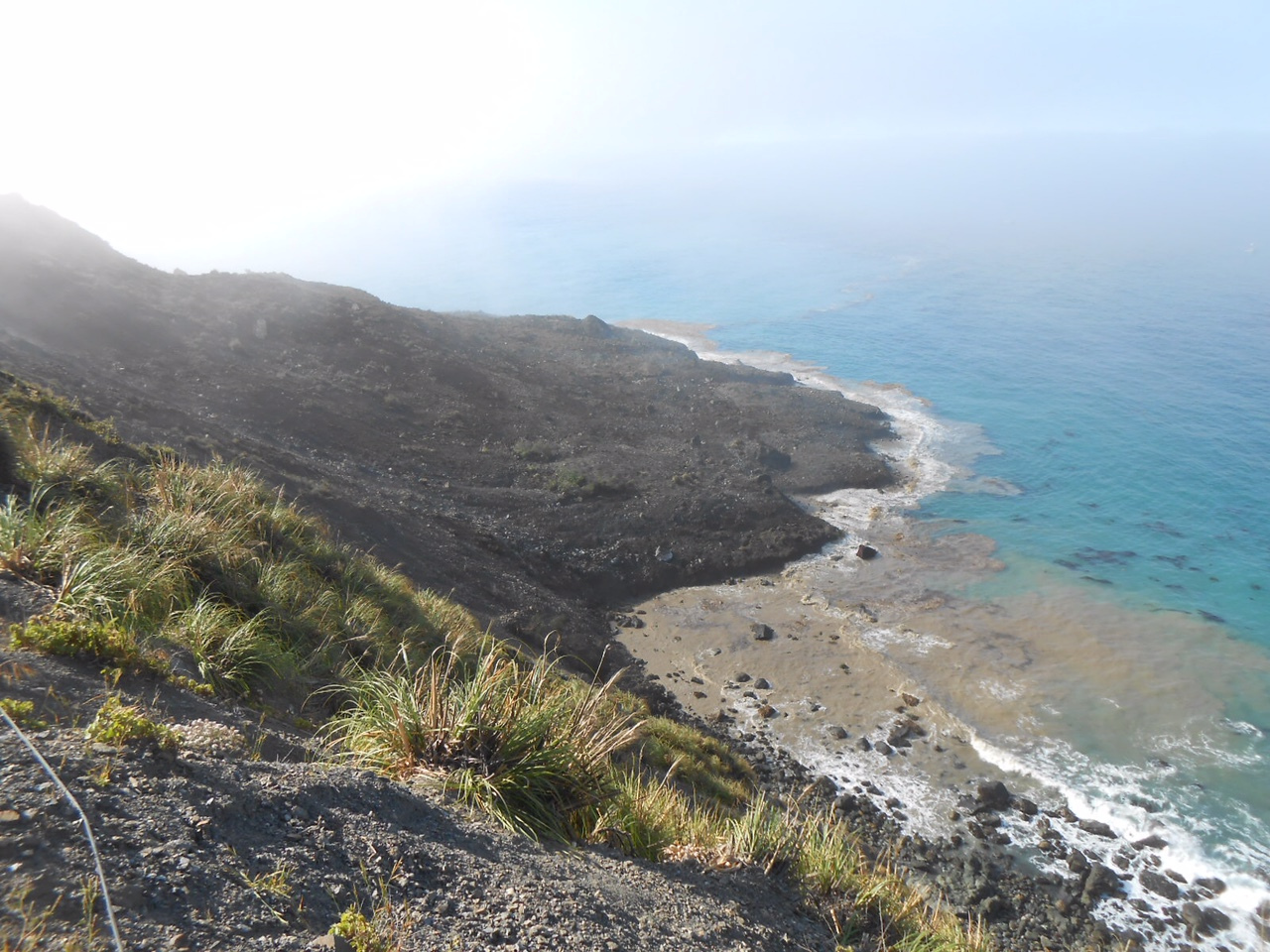
Punta Barro: Big Sur’s newest geographical feature (photo credit: Rock Knocker)
The Santa Lucia Mountains are very young. At just 5 million years old, they are still in the process of being born – punching upward out of the Pacific faster than the forces of wind, waves, rain, and gravity can wear them down. Their steep, unstable seaward wall, rising to over 5,000 feet at Cone Peak, is constantly eroding, sliding and collapsing into the sea.
This natural process has been greatly accelerated since the 1930s, when the construction of Highway One undercut and activated treacherous slopes and old slide zones from one end of Big Sur to the other.
Mud Creek is one of those treacherous slopes. It’s not even really a creek; just a highly saturated mountainside that constantly oozes mud and water and tends to creep or slide downhill during the rainy season. It’s been a problem area since the Highway was built.
In the 1960s, the Highway at Mud Creek featured a floating bridge. This was a bridge structure that, instead of spanning a canyon, sat directly on the ground or, in this case, the mud. As the slope crept downhill, the bridge would travel with it, slowly moving out of alignment with the Highway. Whenever it moved too far, Caltrans would simply drag it back up the slope and back into place.
Perhaps the mud dried out a bit at some point, because the floating bridge disappeared long ago and most locals eventually forgot a place called Mud Creek even existed.
That all changed this year, as persistent rains reactivated Mud Creek and made it one of the most problematic spots, among many problematic spots, along the coast. Weeks, if not months, ago, Big Sur Kate began warning that an immense amount of material appeared to be mobilizing above the Highway at Mud Creek and that a very large slide appeared imminent. She was right.
Last weekend, a very large and deep-seated landslide occurred at Mud Creek; a slide large enough to create a small new point and cove, significantly altering the shape of the shoreline in the area. No one seems to have even tried to estimate the size of the slide at this point. Caltrans simply describes it as “millions of tons.”
Besides inspiring awe, the slide has inspired a good deal of worry over the amount of time it may take to rebuild the Highway in the area. At this point, it is impossible to say how long that might be. As Caltrans will have to knock down or excavate any highly unstable material left above the Highway, before they can rebuild, everything depends on how much mud and rock remains poised to come down and how hard it will be to remove or stabilize it.
After Big Sur’s last major slide, the Julia Pfeiffer Burns slide in 1983, so much unstable material remained that the Highway stayed closed for over a year, while Caltrans undertook the largest earth-moving operation in their history. How much material will need to be removed at Mud Creek, and how long it will take, can’t be known until geologists have finished evaluating the remaining slopes – a process which it may not yet be safe enough to even begin.
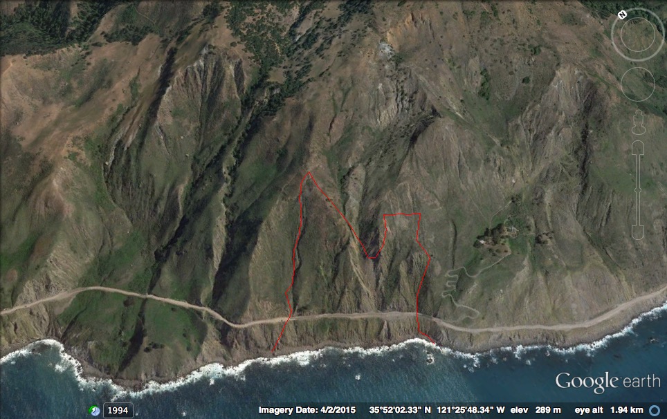
The approximate boundaries of the area that collapsed in last weekend’s slide are marked in red. Large as this slide was, it appears that only the lower portion of the Mud Creek slide zone failed in this event. With this buttressing gone, failure of higher altitude slopes may now be more likely.
Unfortunately, as can be seen in this pre-slide image from Google Earth, last weekend’s slide, big as it was, did not extend anywhere close to the top of the active slide area at Mud Creek. This suggests that a huge quantity of very unstable material may still be up there and that this slide event may be far from over.
It now seems likely that, until the new Pfeiffer Gulch Bridge is finished (hopefully in September), the only vehicular access to the coast between Pfeiffer Gulch and Mud Creek will be over the long, twisting, frequently one-lane, Nacimiento-Fergusson Rd.
This is a stretch of coast the includes Pacific Valley, Kirk Creek Campground, Limekiln State Park, the Camaldolese Hermitage, Lucia, Big Creek, Esalen Institute, Julia Pfeiffer Burns State Park, Deetjens, the Henry Miller Library, Nepenthe, Post Ranch, Ventana Inn, the Big Sur Bakery, and many other popular destinations.

The Mud Creek slide in relation to the “town” of Gorda (which also sits on an active slide). The Mud Creek slide zone appears to extend all the way up slope to the yellowish head scarp in the upper right hand corner of this image.
As Gary Griggs, Kiki Patsch and Lauret Savoy put it in their excellent book Living With the Changing California Coast (highly recommended reading for coastal residents):
From Pacific Valley to the southern end of Big Sur at San Carporforo Creek, the terrain again becomes very steep and rugged. This entire section contains some of the weakest rock (serpentinite) of the Franciscan complex and is very prone to landsliding. Some development, single-family homes and small ranches, exists on the steep slopes west of Highway 1, even though the risk from landslides is quite high. The town of Gorda is built within a large ancient landslide complex. The interior portion of this large slide continues to slip on smaller, active slide planes, resulting in very high landslide risks.

XT, you are absolutely right. This slide is FAR from over. In one of the direct frontal photos I have marked several cracks on the north side that will giving way in the next few weeks, or so. Despite what Cal Trans says, one can see this was NOT one event, it was three. There are clearly 3 separate shelves on the alluvial fan visible in many of the photos, at least the ones Rock Knocker took and are posted in my slide show. I will change that to individual photos, so people can study it, and send my photo with cracks marked privately via email.
As always, thanks for the great history and geology lesson. Rock Knocker thanks you, too.
Thank you, Keith.
What a fascinating post. Thanks for that. Drove that stretch of Highway 1 in 2014 and 2015 with my wife on a trip up from San Diego. Previously, I hadn’t been there since the early 1990s. It’s a lovely place to visit. Maybe the closure will do the environment and area some good. I don’t know. Here’s hoping all works out for the best.
As geograpaphic phenomenon as a former PhD candidate geographer I was totally unaware of. Facinating.
Thank you for this article regarding Mud Creek. What you wrote makes perfect sense, and I have a better understanding of what is going on there. Can I just say, what a mess!
Very interesting article – things I had not known. Thank you.
Reblogged this on carmelhomesblog.
Only article that gave enough facts to tell me the location. Would have buried the Pitkins Curve rock shed!
Prior to the JFB slide in ’83, the coast experienced a three year drought ’75-’77. Slopes shrink during droughts, and when the deluge arrives, subterranean rivulets can accelerate liquefaction. Another aspect is the changing outfall of springs. During the drought of the mid-’70’s, Caltrans workers noticed that the uphill springs above Sycamore Draw occasionally moved about indicating that there was hydraulic movement underground. That hill became the smaller of the two 1983 great slides to the Pacific.