For more recent updates, see Soberanes Fire: Week Three and Soberanes Fire: Week Four

For earlier maps and notes see Soberanes Fire: Week One
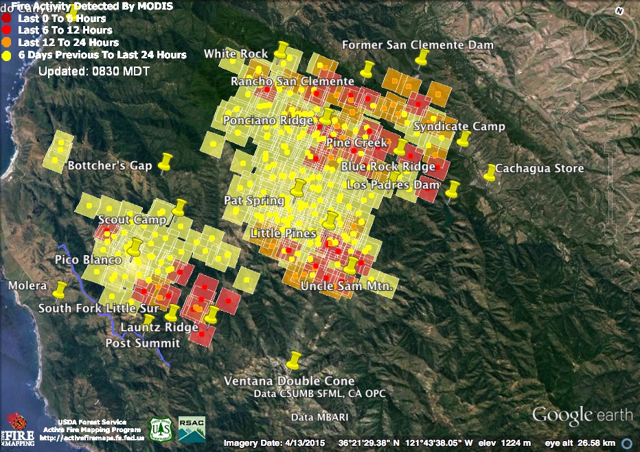
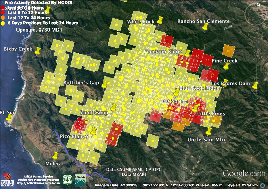
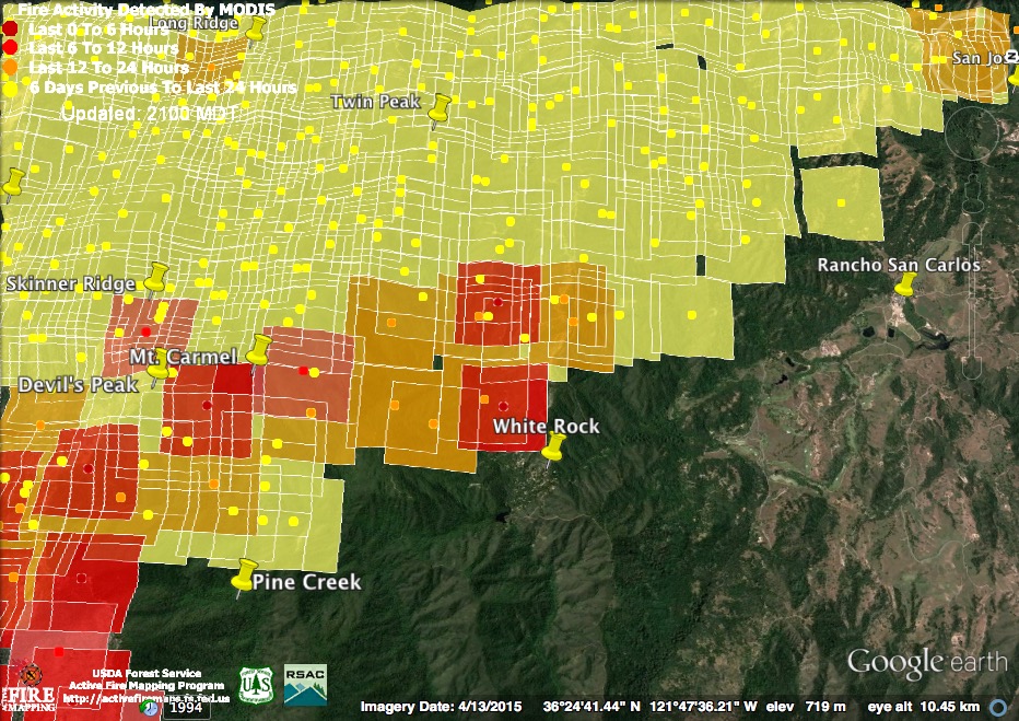
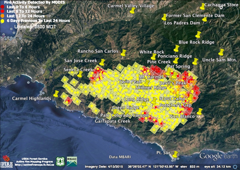
Important caveats: Please note that the squares on the heat detection maps represent the expected margin of error, not the size of the area burned. In other words, the detection could have come from anywhere within the square. Also be aware that false detections do sometimes occur. An outlying or “over the line” heat detection is not, by itself, a confirmation that there is fire in the area indicated. In addition, the satellites do not detect heat everywhere that fire exists. Creeping, backing or smoldering fire is often not detected. Finally, the detections are only snapshots of moments in time. Flare ups that occur before or after a satellite pass may be entirely missed.
Also be aware that yellow squares disappear from the map after 6 days. These are not maps of the area burned since the fire began, just maps of where heat has been detected during the past week.
8-4-16 8:15 pm Maps & Notes
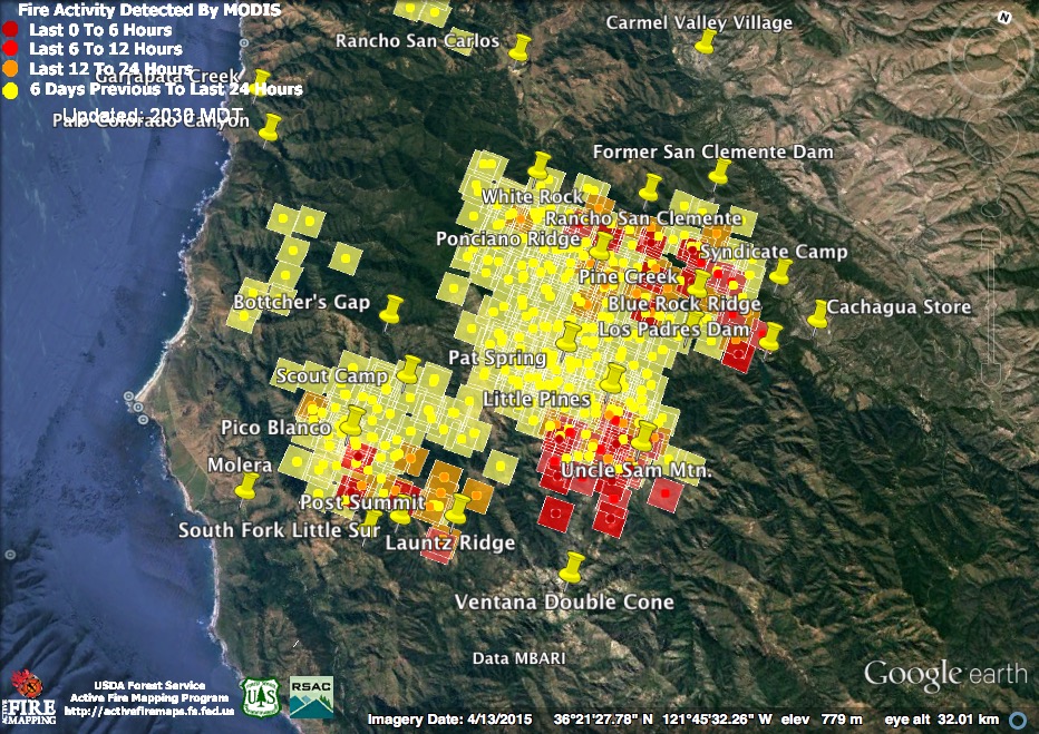
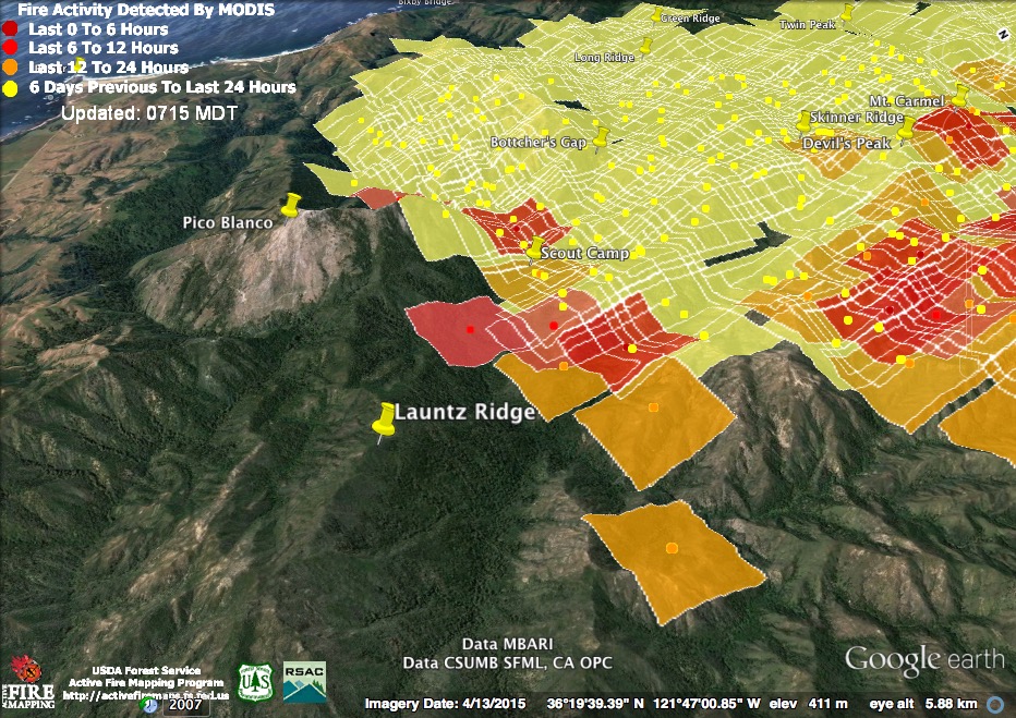
Things were beginning to cool down along the northern line from White Rock to Cachagua today, but the fire was on the move again in the south. Light red squares were detected around noon, dark red squares around 2:00 pm.
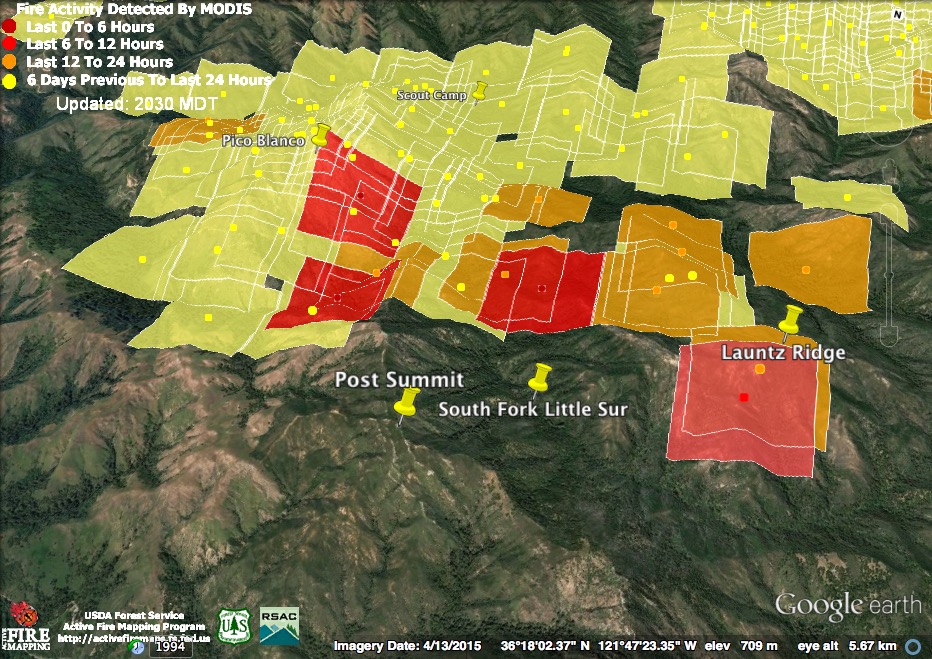
The fire’s progress along Launtz Ridge appears to have slowed this afternoon, but that’s not surprising considering that it’s reached a high point and must now back down to a saddle. Meanwhile, the 2:00 pm pass found renewed heat in two locations deeper in the canyon of the South Fork Little Sur, and on the east face of Pico Blanco. No new heat was detected on Dani Ridge.
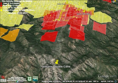
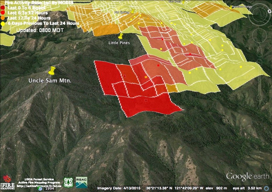
Yesterday I wrote that the fire around Uncle Sam Mountain looked poised to run up the high brushy ridge to the Ventana Double Cone and today it began to do it. The detections suggest a broad fire front stretching well into the Little Sur and Carmel River watersheds on either side of the ridge.
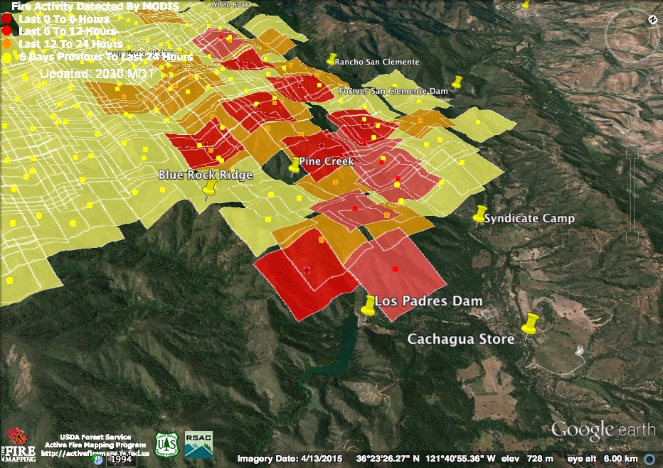
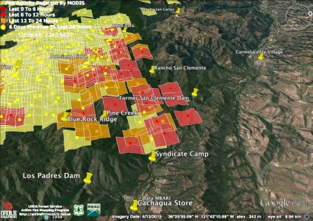
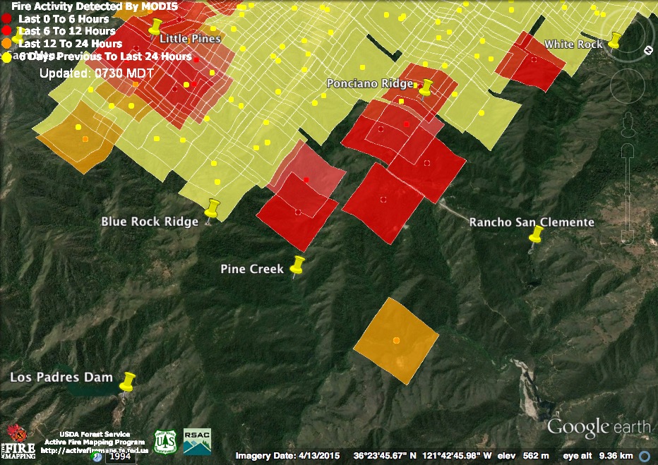
Just as you’d expect in a successful burn out operation, intense heat has moved away from the control lines and back into the main fire between White Rock and Syndicate Camp. At the bottom of Blue Rock Ridge, on the other hand, just above the Los Padres Dam, fire continues to burn actively in close proximity to inhabited zones.
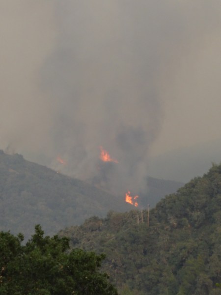
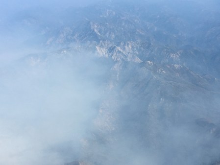
(Photo Credit: Jeff Niewenhuis)
This evening’s official numbers: 51,200 acres; 30% contained; 57 homes and 11 outbuildings burned; 3 homes and 2 outbuildings damaged.
8-4-16 8:30 am Maps & Notes
The satellites found heat in all the usual places overnight. Detections are from around 10:30 pm and 3:00 am.

The fire continued its active expansion along Launtz Ridge overnight and heat was again detected to the west of Pico Blanco, on Dani Ridge. The fire on Launtz Ridge will likely continue to move toward the Ventana Double Cone and the Big Sur River watershed.
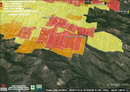
The fire continued to burn hot around Little Pines and Uncle Sam Mountain, but the satellites found no sign of further expansion in this area last night.

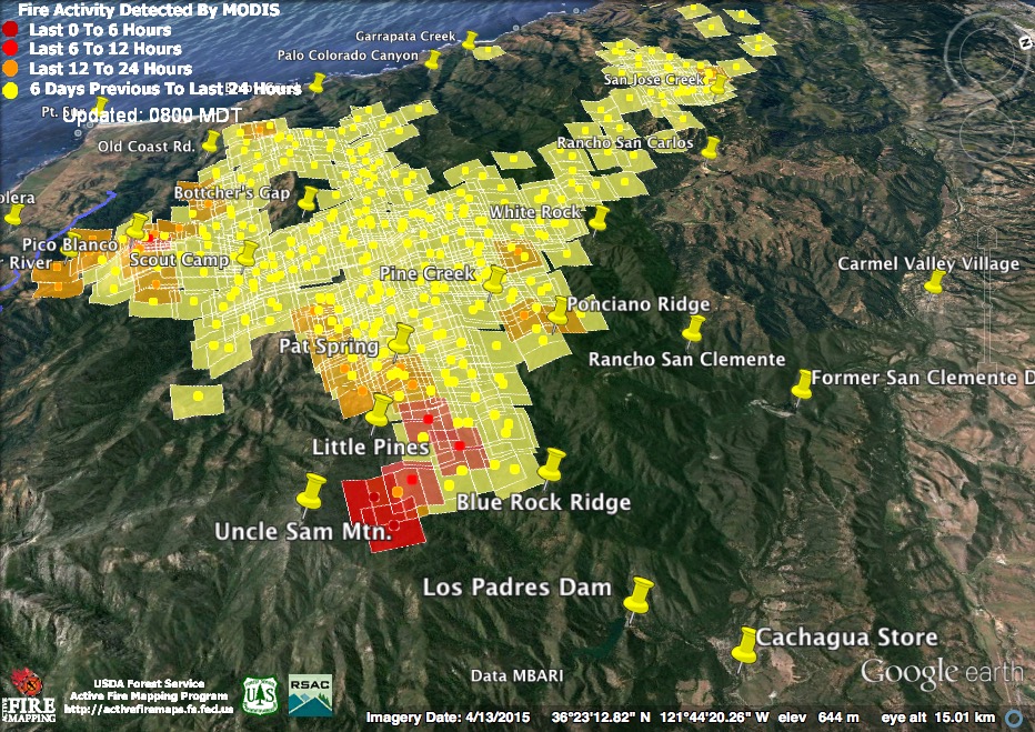
The new heat detections in the area of the ongoing burn out operations, between Cachagua and White Rock, all fall neatly within the control lines. Most notable, is that the fire, likely due to the line being fired, is now all the way down to the end of Blue Rock Ridge and overlooking the Los Padres Dam.
Last night’s infrared map, prepared around 9:00 pm, shows nearly all the expansions of fire area indicated by the later satellite passes. This suggests the fire was most active earlier in the evening.
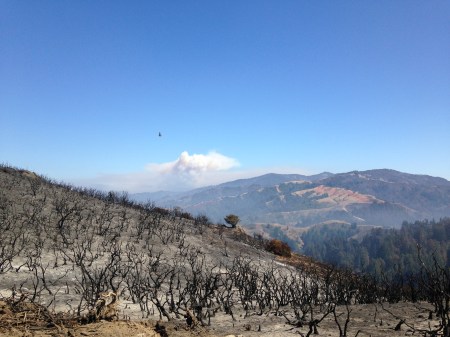
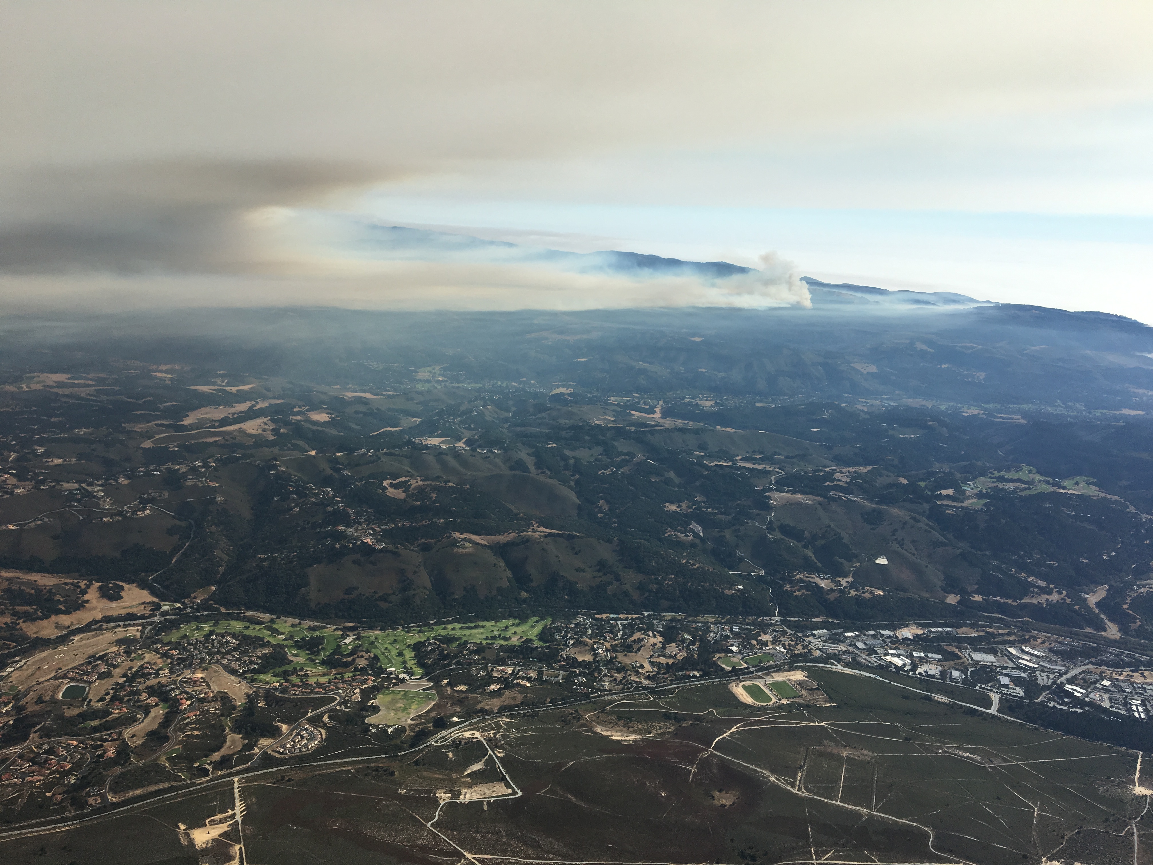
The fire has covered a lot of territory in two weeks (Photo Credit: Tim Jensen)
Continuing Mystery: Still wondering about the “Proposed Fire Lines” the Operations Map shows running along the bottoms of rivers and creeks, traversing extreme slopes, climbing waterfalls, etc. The fire on Launtz Ridge has already outflanked he proposed line in the Little Sur watershed and it is difficult to believe the line from Los Padres Dam up the Carmel River, over the Double Cone, and down Ventana Creek and the Big Sur River could possibly be completed in time – even if someone was crazy enough to try building a line through that terrain. Does anyone know where this idea came from or if there are crews out there trying to implement it?
This morning’s official numbers: 51,000 acres; 27% contained; 57 homes and 11 outbuildings burned; 3 homes and 2 outbuildings damaged.
8-3-16 10:30 pm Maps & Notes
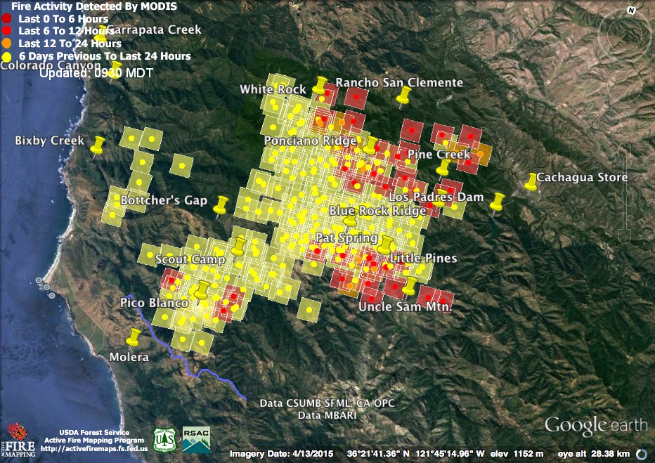
The fire remained pretty active during the day today and, judging from the smoke, got still more active later in the afternoon. These heat detections were recorded around 11:30 this morning and 2:45 this afternoon. Burning only appeared to get more intense as the afternoon wore on, with an enormous column rising around 6:00 pm.

At the southern end of the fire, near Pico Blanco, flames now appear to be advancing along the top of Launtz Ridge. This path will conduct the fire into higher and drier territory, eventually bringing it to the edge of the Big Sur River watershed above Ventana Creek.
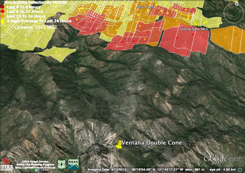
The fire around Uncle Sam Mountain continued it’s southward spread today, and now appears poised for a run up the long, brushy ridge to the summit of the Ventana Double Cone.
The fire and burn out operations between White Rock and Cachagua were also extremely active today. By late afternoon, the ferocity of the burning was causing concern in Cachagua and Carmel Valley, but there is no indication that fire has established itself on the wrong side of the control lines.
Mystery of the day: Today’s North Operations Map, which shows a network of proposed fire lines criss-crossing the Ventana Wilderness in some very odd locations. One would head up the bottom of the North Fork Little Sur, eventually crossing the high ridge north of the Ventana Double Cone and descending to the Carmel River. Another would run up the bottom of the Big Sur Gorge, then up the bottom of Ventana Creek to the Ventana Double Cone. Given the extreme terrain these lines would cross, and the herculean labor that would be required to build and fire them prior to the arrival of the fire, I have to wonder whether the map makers were using the proposed fire line symbol to indicate something else. They have, after all, surrounded the Double Cone with a ring of “Division Break” symbols. What that’s supposed to mean is another mystery. If anyone can shed light on this, please let me know.
This evening’s official numbers: 46,700 acres; 27% containment (all the official websites and information sheets still say 25%, but Cal Fire PIO Berlant has Tweeted that containment is at 27%, so I’m going with that); 57 homes and 11 outbuildings burned; 3 homes and 2 outbuildings damaged.
8-3-16 9:30 am Maps & Notes
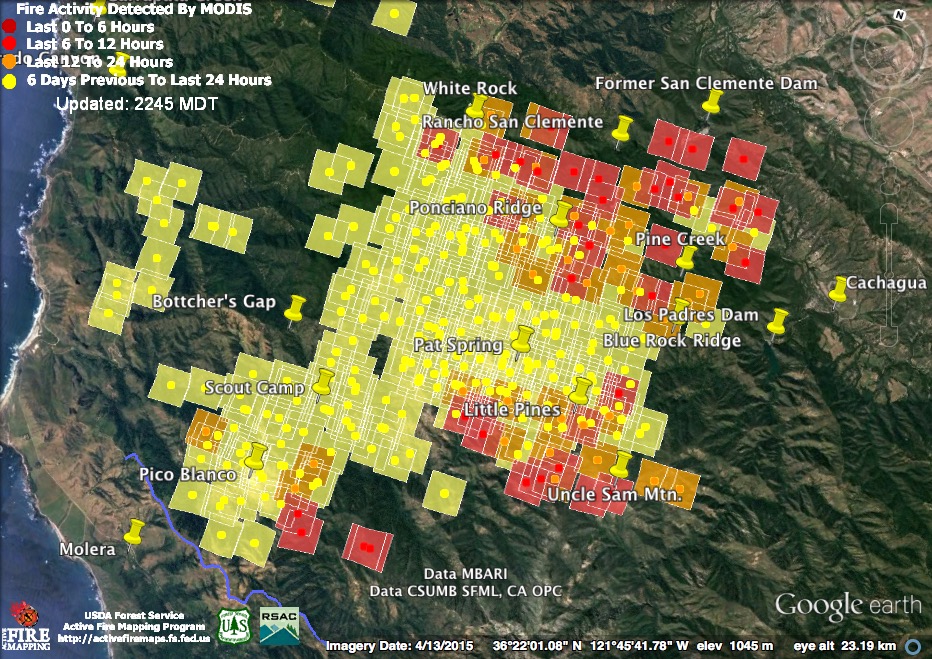
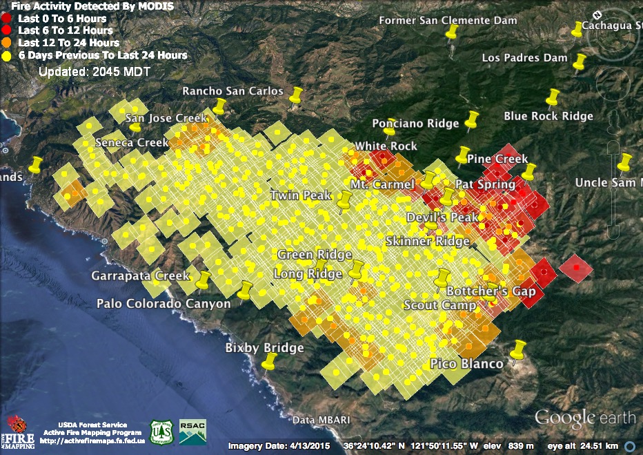
The fire, as usual, was more active during the night than during the day. Fire to the east and west of Pico Blanco (on Dani and Launtz ridges) was detected by the satellites again; the main fire front pushed deeper into the Ventana Wilderness around Uncle Sam Mountain; and both the main fire and the burn out operations along the northern front, from White Rock to Cachagua, were also very active. The new heat detections are from around 11:30 pm last night and around 3:30 am this morning.
The latest heat detections suggest that the fire is moving south from Little Pines, burning around Uncle Sam Mountain to the west, toward the Puerto Suelo saddle and exiting the Rattlesnake Creek drainage through the gap between Uncle Sam and Elephant mountains. This fire may now be backing toward the Carmel River in the vicinity of Sulphur Springs and Buckskin Flats camps.
Even if the marine layer continues to suppress burning at lower elevations, the fire is likely to have no problem moving up the high ridge from Puerto Suelo to the Double Cone and, from there, on south down the spine of the Santa Lucia Mountains.
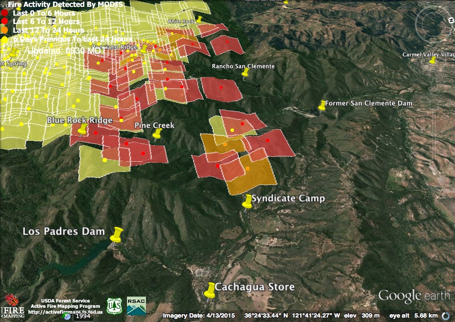
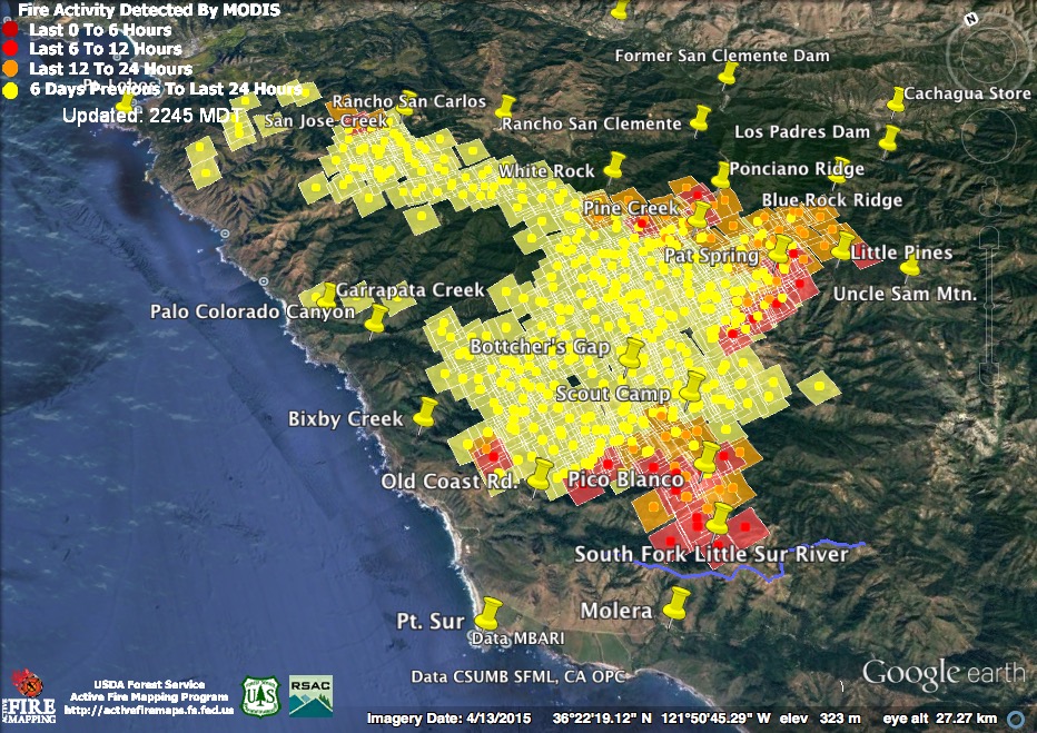
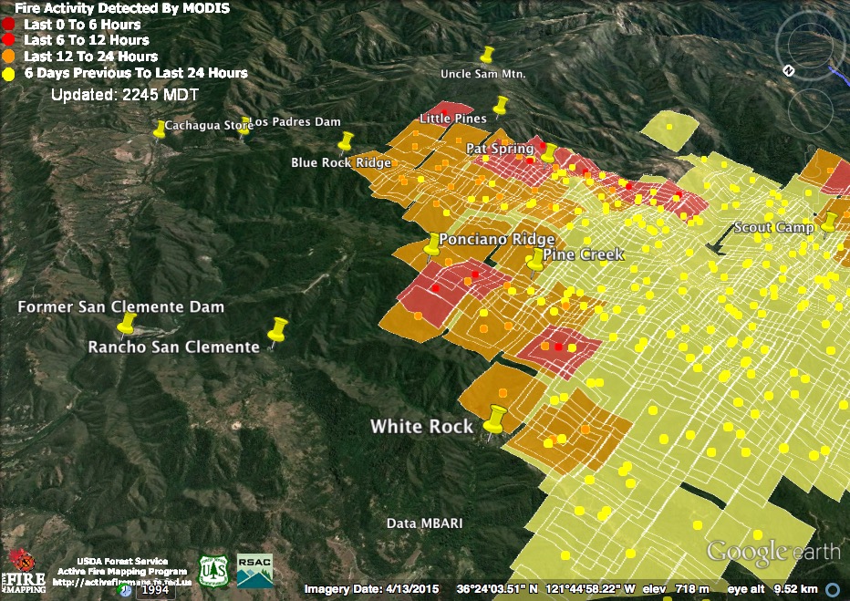
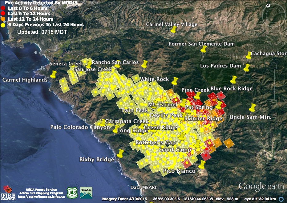
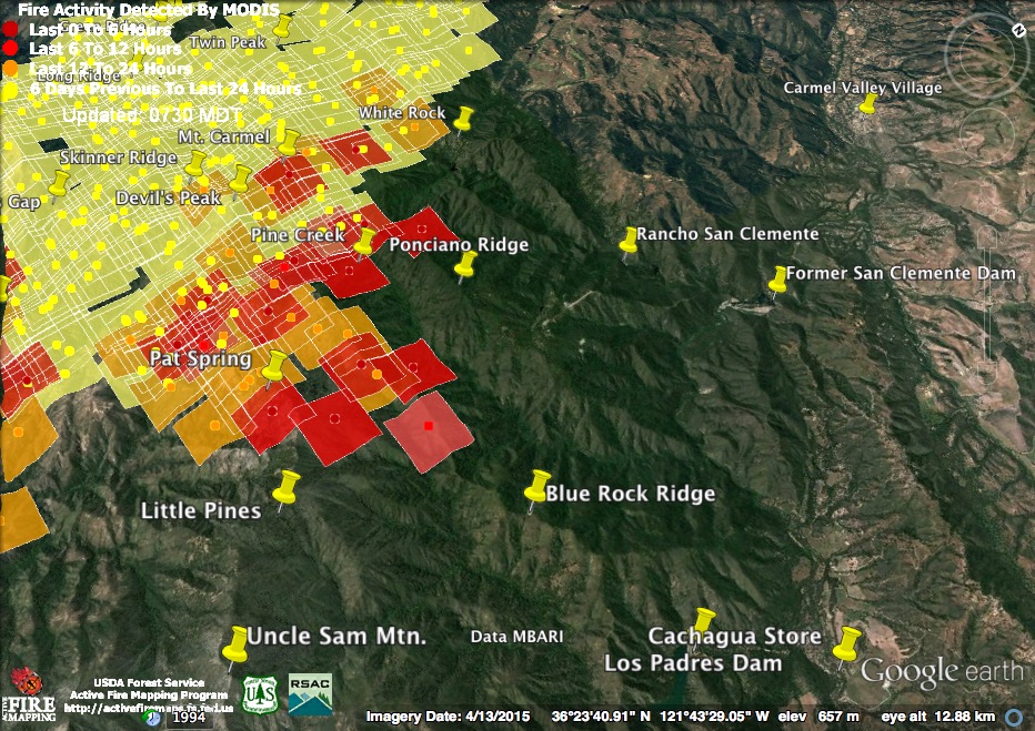
The burn out operation on both sides of the Carmel River downstream of Syndicate Camp, in Cachagua, was clearly visible to the overnight satellites. The main fire on Blue Rock Ridge also appears to have had an active night. Heavy burning was detected throughout upper Pine Creek and on both sides of Ponciano Ridge. The outlying heat detections near Rancho San Clemente and White Rock, on the other hand, are the result of burn out operations. Thanks to the favorable conditions that have made these extensive burn out operations possible, the fire is unlikely to progress further to the north toward Carmel Valley.
These burn out operations are clearly visible on this morning’s infrared map (based on data acquired at around 7:00 pm yesterday), but the advance of the main fire front around Uncle Sam Mountain, which probably happened later, is not shown.
Night in Cachagua (Photo Credit: David J. Gubernick)
This morning’s official numbers: 45,800 acres; 25% containment; 57 homes and 11 outbuildings burned; 3 homes and 2 outbuildings damaged.
8-2-16 10:30 pm Maps & Notes
The fire continued burning in the Little Pines area today and appears to have spread a little further into the Little Sur basin. Major burn out operations, stretching from Cachagua to White Rock, were responsible for the rest of today’s heat detections – as well as for spectacular leaping flames visible from Carmel Valley. The detections on the map are from around 12:15 and 2:00 this afternoon.
The big news of the day was the announcement that the fire was started, as widely suspected, by an illegal campfire. Neither camping, nor fires, are allowed at Garrapata State Park, but some person, or persons, apparently decided to hike up to the end of the trail along Soberanes Creek and build a campfire. That was less than two weeks ago and that campfire has so far burned 57 homes, driven hundreds of other people away from their homes, disrupted the lives of thousands more, and led to the death of a firefighter. By the time it’s over it will probably have consumed in excess of 150,000 acres, pumped tons of carbon into the atmosphere, and rank among the largest and most expensive fires in the history of the state.
This evening’s official numbers: 44,300 acres; 25% containment; 57 homes and 11 outbuildings burned; 3 homes and 2 outbuildings damaged.
8-2-16 7:30 am Maps & Notes
As usual, the fire was a bit more active during the night. Light red squares were detected around 10:45 pm last night and dark red squares around 3:00 am this morning.
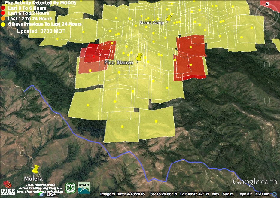
Near Pico Blanco, the fire appeared to be moving east and west, rather than south toward the Big Sur Valley. To the west, the satellites found fire spreading across Dani Ridge and, to the east, a fire front stretching from the bottom of the North Fork Little Sur to the top of Launtz Ridge.

Intense fire continued to burn overnight in the Little Pines area.
Most, if not all, of the new heat detections between Blue Rock Ridge and White Rock are the result of ongoing burn out operations. There were no new heat detections from close to the Carmel River – probably because the marine layer kept the burning there too slow to be noticed by the satellites.
Some of the burn out operations appear on this morning’s infrared map (from around 2:00 am), as does the east/west expansion around Pico Blanco.
This morning’s official numbers: 43,400 acres; 18% containment; 57 homes and 11 outbuildings burned; 3 homes and 2 outbuildings damaged.
8-1-16 9:00 pm Maps & Notes

The deepening marine layer kept a lid on the fire everywhere but at the highest and driest elevations today. Light red squares were detected around 11:45 am and dark red squares around 3:00 pm.
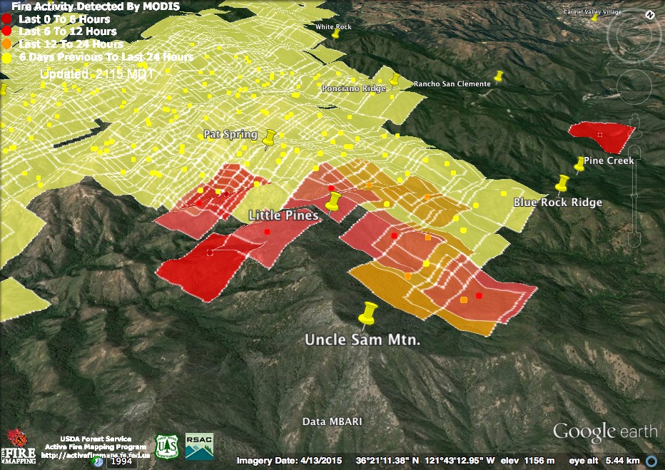
These detections suggest continued fire spread on both the Little Sur and Rattlesnake Creek sides of the high Little Pines Ridge.
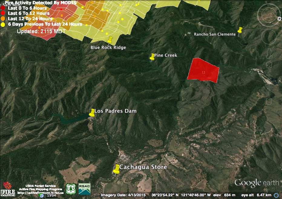
This outlying 3:00 pm heat detection, located near the Carmel River upstream of the San Clemente Dam site, is neither a spot fire nor an error. It is the beginning of the burn out operations intended to prevent the fire from entering the Cachagua Valley. Those operations are now in full swing.
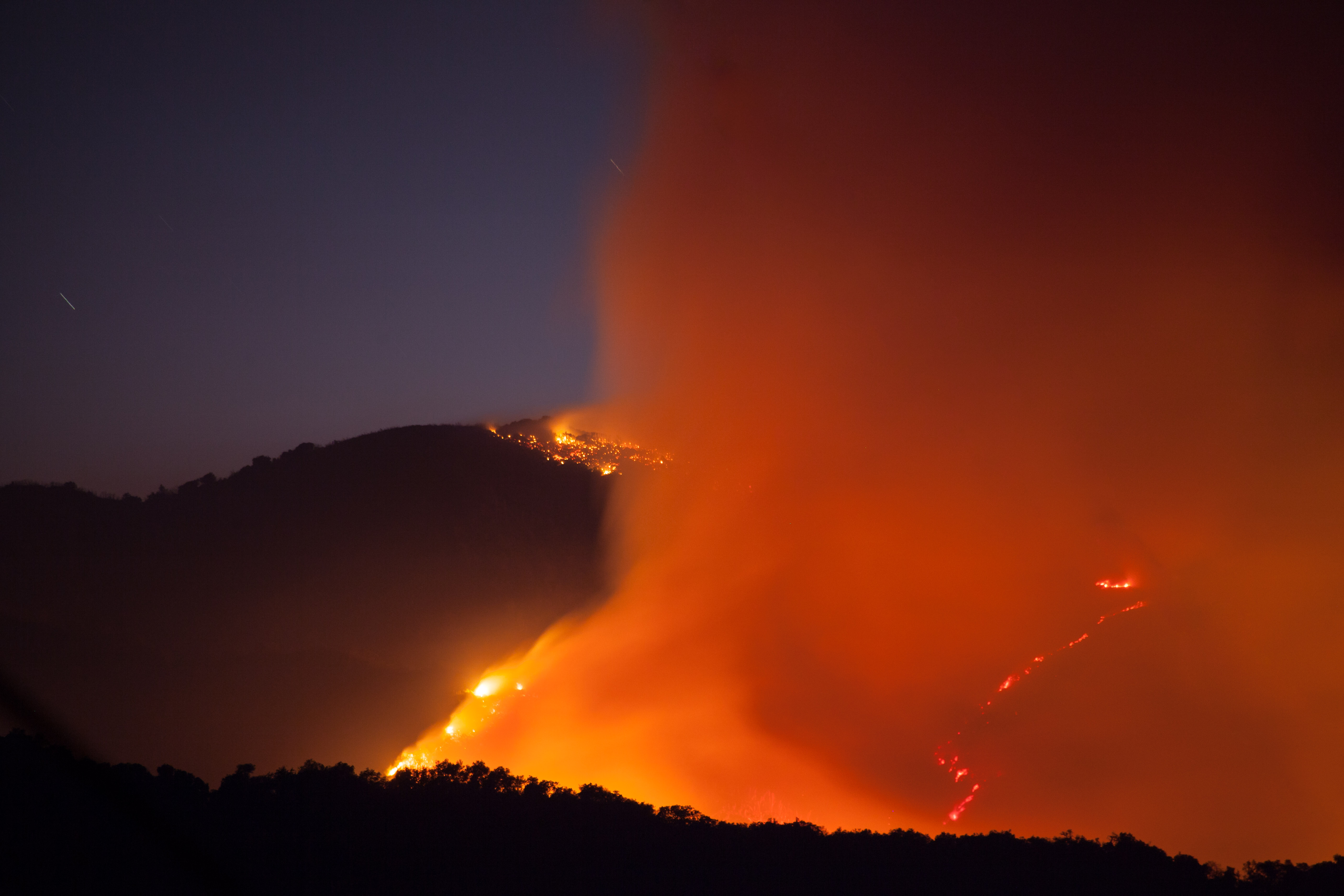
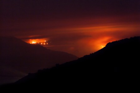
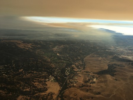
The fire, as it appeared from Cachagua on Saturday night. (Photo credit: David Gubernick)

All quiet on the Northern Front. Mop up now underway on the lines behind the Carmel Highlands. (Photo Credit: Tim Jensen)
This evening’s official numbers: 40,700 acres; 18% containment; 57 homes and 11 outbuildings burned; 3 homes and 2 outbuildings damaged; estimated final acreage 170,000; estimated final cost of suppression $80 million; current cost per day $6 million.
8-1-16 7:30 am Maps & Notes
It looks like the fire has finally had a relatively quiet night. With the exception of some burning near the summit of Pico Blanco, the only heat detected overnight was on the fire’s eastern edge. The light red squares were detected at around 2:15 am and the dark red squares at around 4:00 am. Those following the fire’s progress toward the Big Sur Valley should note that last night’s infrared map (prepared around 9:00 pm) indicates that, at that time anyway, the fire remained north of the South Fork Little Sur.
The 2:15 am satellite pass found heat, but not much evidence of expansion, on the fire’s eastern edge. The 4:00 am pass, on the other hand, found fire actively spreading across the Rattlesnake Creek watershed beneath Uncle Sam Mountain and Little Pines.
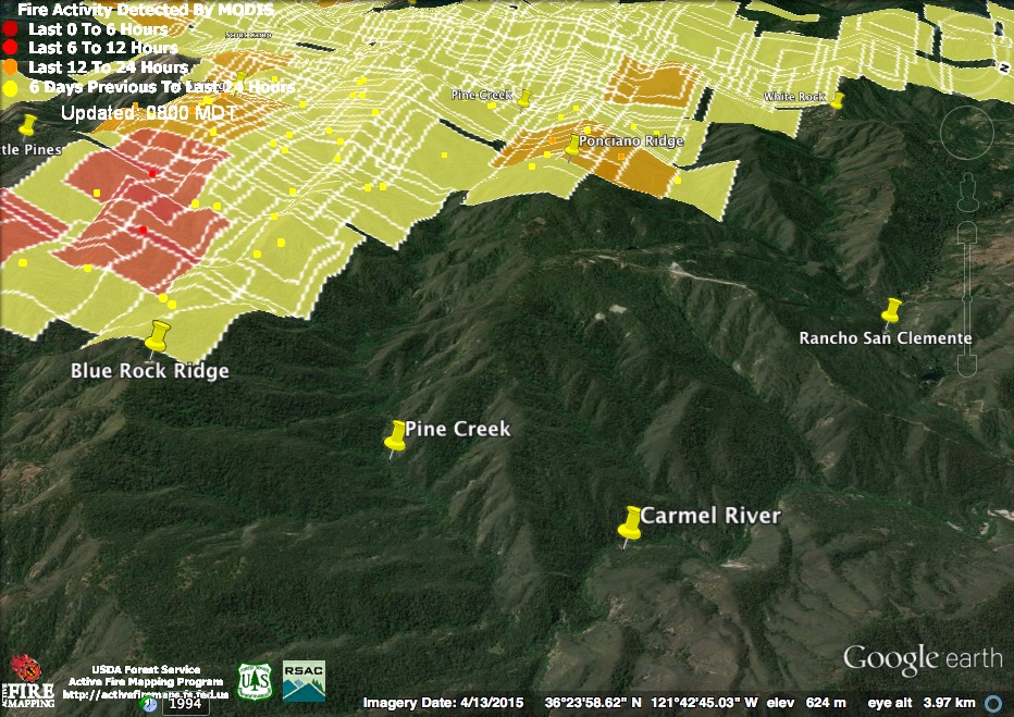
No new heat was detected between Blue Rock Ridge and White Rock, but there are reports (and photos) of fire burning very actively on the Pine Creek side of Blue Rock Ridge earlier in the evening. Last night’s 9:00 pm infrared map actually shows a spot fire ahead of the main fire front on Blue Rock Ridge.
There was also an attempt to keep the fire creeping down Ponciano Ridge away from Rancho San Clemente by starting a burn out operation from the Rancho San Clemente airstrip (the white line to the left of Rancho San Clemente) last night. Unfortunately, the effort had to be abandoned due to unfavorable winds.
The San Clemente Rancho FB page is a good source of information on this end of the fire.
This morning’s official numbers: 40,618 acres; 18% containment; 57 homes and 11 outbuildings burned; 3 homes and 2 outbuildings damaged; estimated final acreage 170,000; estimated final cost of suppression $80 million; current cost per day $6 million.
7-31-16 10:30 pm Maps & Notes
Like yesterday, the fire was active during the day today, but did not make major runs like it did during the night. The new heat detections are from around 12:30 pm and 2:00 pm this afternoon.
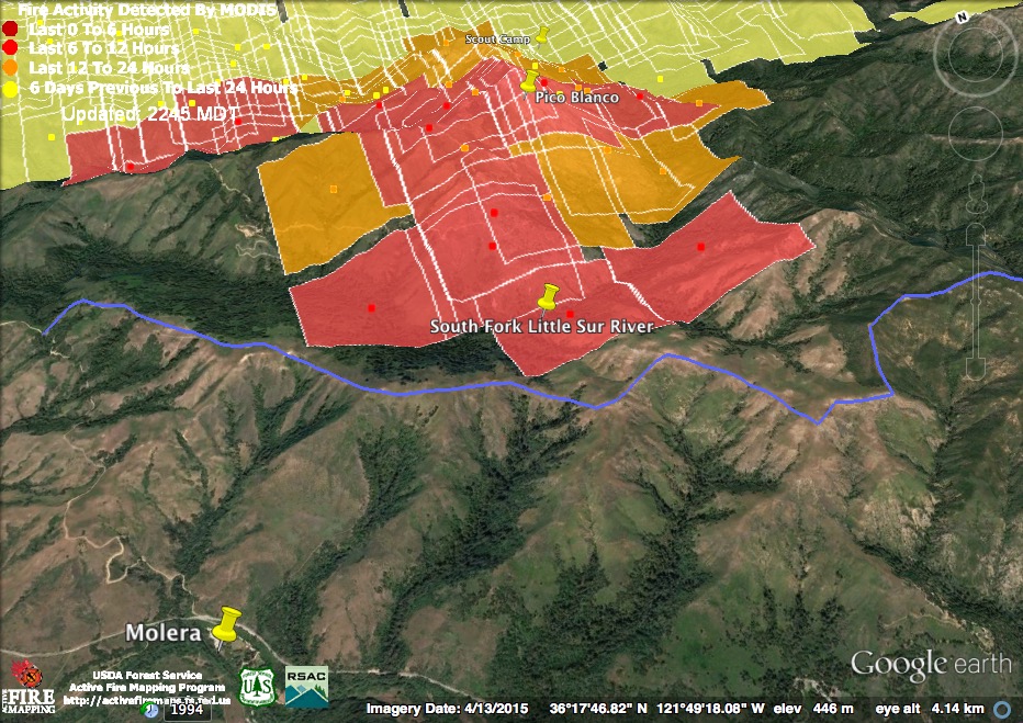 The Pico Blanco area was one of the more active spots during the day today and these detections suggest that fire may have crossed the South Fork of the Little Sur River. Either way, it will be climbing toward the fire break on East Molera Ridge soon enough.
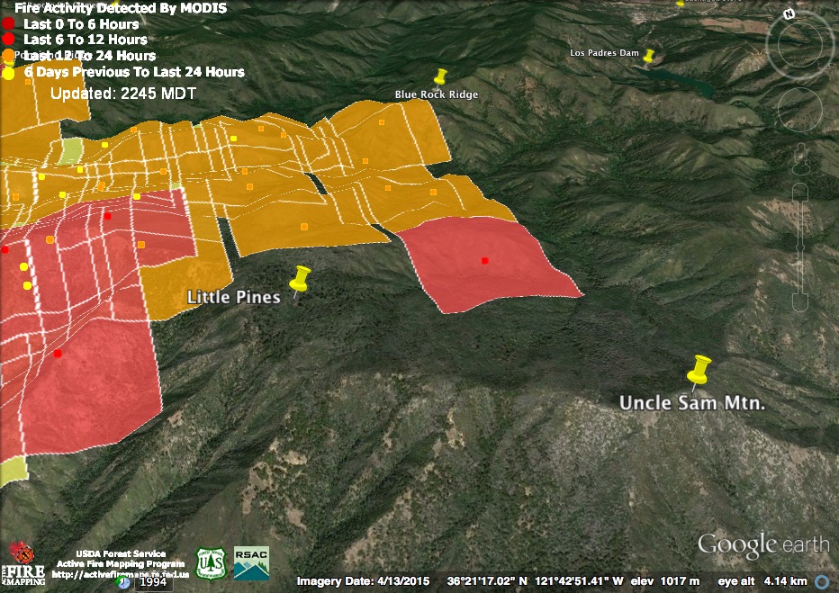
Last night’s big run down Danish Creek and Blue Rock Ridge cooled off during the day today, but intense burning continued below Pat Spring, in the Little Sur watershed, and the fire appeared to move south into the Rattlesnake Creek drainage, below Little Pines and Uncle Sam Mountain.
The fire also remained hot on Ponciano Ridge, above Rancho San Clemente, but there were no fresh heat detections in the White Rock area.
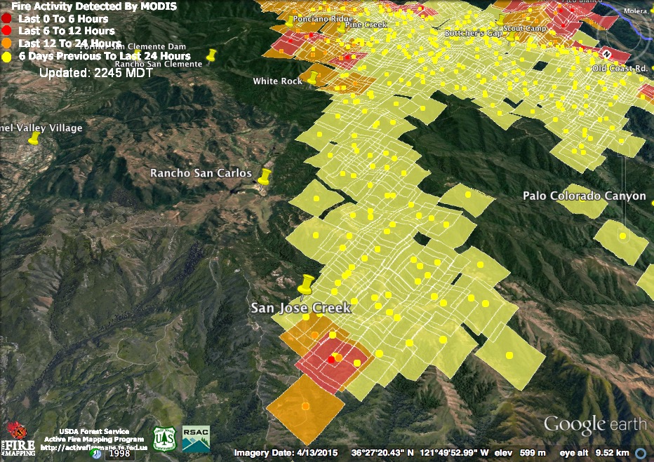
At the north end of the fire, things were still hot along Rancho San Carlos Rd., in the San Jose Creek area. Crews have been working to burn out areas to the west of RSC Rd. for many days now.

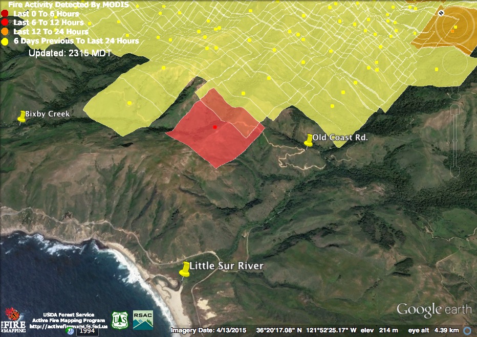
Significant heat was still being generated near the top of Serra Grade and fixed wing planes were making drops in this area today to assist firefighters in keeping the fire east of the Old Coast Rd. There was also renewed heat along the North Fork of the Little Sur below Dani Ridge.
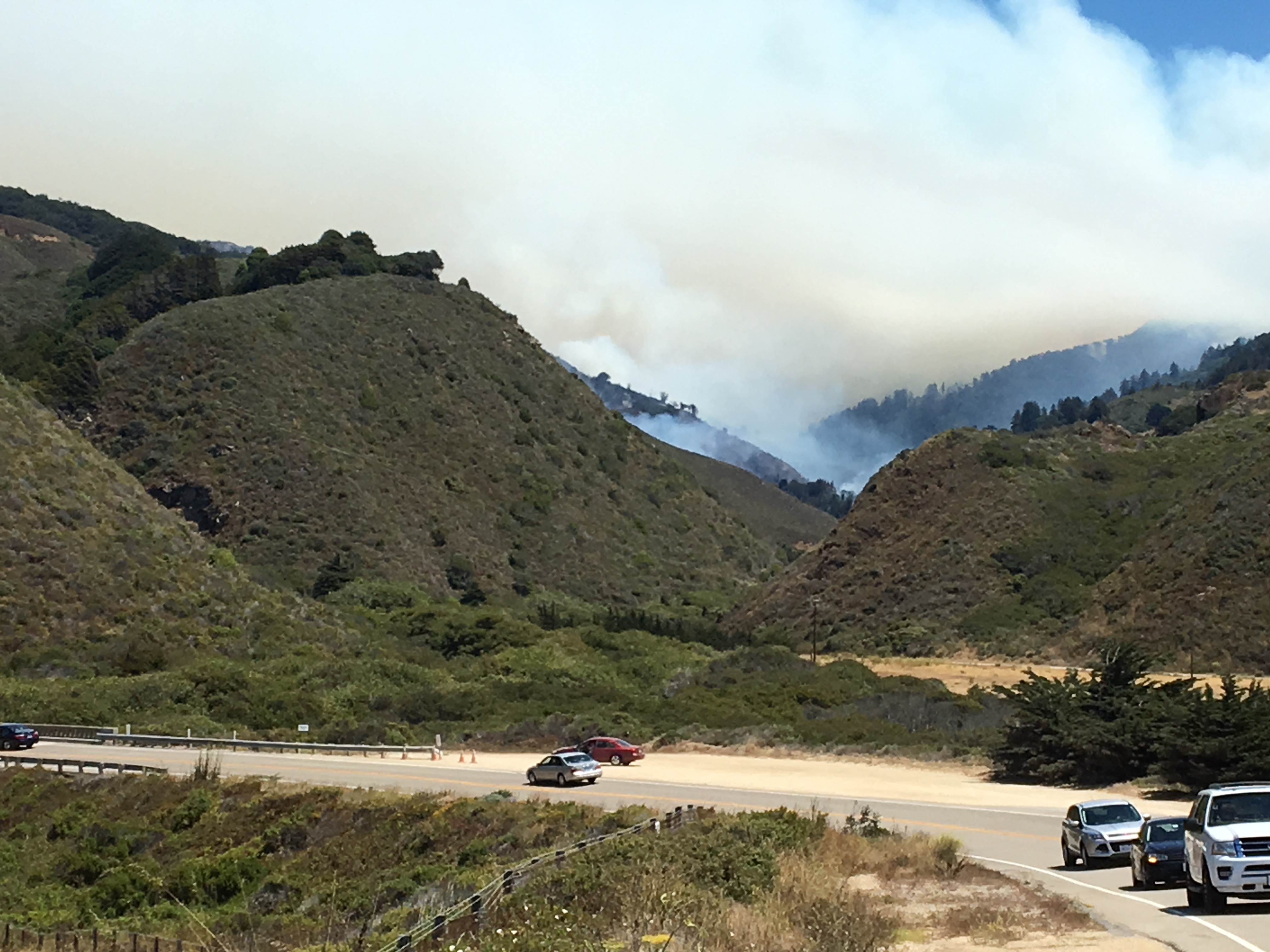
View up the Little Sur River at 1:00pm this afternoon.
This evening’s official numbers: 40,000 acres; 18% containment; 57 homes and 11 outbuildings burned; 3 homes and 2 outbuildings damaged; estimated final acreage 170,000; estimated final cost of suppression $80 million; current cost per day $6 million.
7-31-16 8:30 am Maps & Notes

A very active night for the fire. Heavy burning around Pico Blanco, in the south, and from White Rock nearly to Little Pines, in the east. The satellites also picked up heat from burn out operations near the top of Serra Grade on the Old Coast Rd. and along San Jose Creek in Rancho San Carlos. Heat detections are from around 11:00 pm last night and around 3:00 am this morning.

There’s been fire on Pico Blanco for the past two days, but last night it looks like it really blew up. If the heat detection on the left is to be believed, the fire may now have crossed Dani Ridge. I’ve drawn in (in blue) the location of the major dozer line from the Old Coast Rd. up East Molera Ridge and on over Post Summit. This is the line intended to keep the fire out of the Big Sur Valley.

In the night’s biggest run, the fire raged through upper Danish Creek and the Big Pines area, moving closer to Cachagua down Blue Rock Ridge. This fire was plainly visible from the Cachagua area last night, resulting in many spectacular photos and videos of leaping flames. Large dozer lines have been opened between the fire and the inhabited portions of Cachagua and Carmel Valley. Firefighters plan to conduct burn out operations from these lines to protect these communities.

The Danish Creek fire front stretched all the way back across Pine Creek and Ponciano Ridge to the White Rock area, where the fight to save the White Rock community continued.
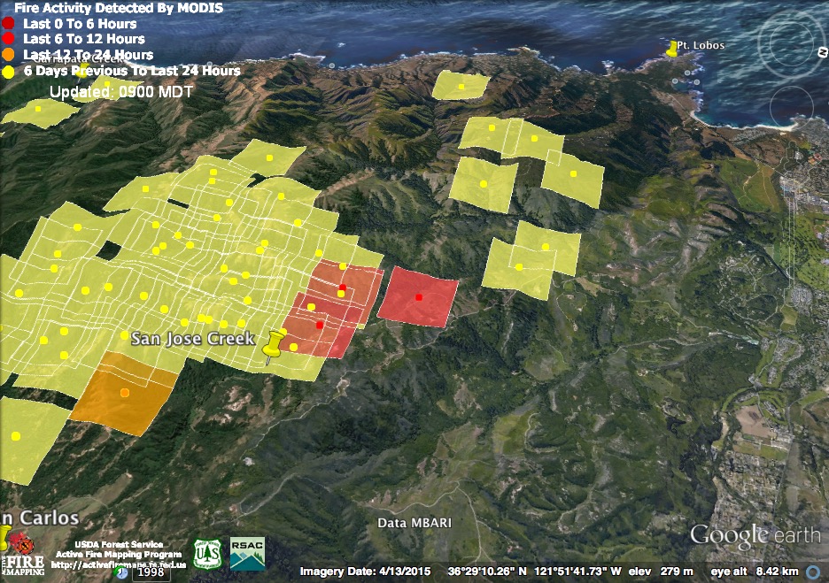
These northernmost heat detections, along San Jose Creek, are part of the continuing burn out operation around the Mitteldorf Preserve.
This infrared map, created around 12:30 am this morning, provides more clues as to what the fire was up to overnight.
This morning’s official numbers: 38,007 acres; 15% containment; 57 homes and 11 outbuildings burned; 3 homes and 2 outbuildings damaged; estimated final acreage 170,000; estimated final cost of suppression $80 million; current cost per day $6 million.
7-30-16 11:00 pm Maps & Notes

New (red) detections from satellite passes at around 12:30 pm and 3:00 pm this afternoon suggest that, while the fire remained active today, it did not expand its boundaries much.
This detection, near the top of Serra Grade on the Old Coast Rd. is almost certainly located entirely on the east side of the road. A burn out operation began yesterday from the road in this location and it was clearly still ongoing today.
The satellites finally managed to detect the fire we saw burning high on Pico Blanco yesterday, so the intensity of the burning in this area probably increased today. There were also reports of a large column rising from this location.
Fire officials confirmed tonight that the fire has burned through the Scout Camp area, but reported that no structures were lost.
The large area from White Rock southeast to beyond Pat Spring that was overrun with fire yesterday continued to burn hot today, but the satellites found no evidence of any significant new expansion.

Today’s northernmost heat detection, near Rancho San Carlos, was likely part of the continuing effort to burn out and contain the fire in this area behind solid lines. I’m guessing that tomorrow morning’s Operations Map will show an increase in the amount of contained perimeter in the Rancho San Carlos area.
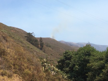
Photo Credit: Ken Ekelund
As always, the satellites missed less intense fire in many other places. This wisp of smoke, for instance, was coming from a small burn out operation that began in the Garrapata area about 12:30 this afternoon.
This evening’s official numbers: 35,540 acres; 15% containment; 57 homes and 11 outbuildings burned; 3 homes and 2 outbuildings damaged; estimated final acreage 170,000; estimated final cost of suppression $80 million; current cost per day $6 million.
7-30-16 7:00 am Maps & Notes
The heavy burning continued along the fire’s southeastern edge overnight. Light red squares were detected around 12:30 am; dark red squares around 2:00 am.
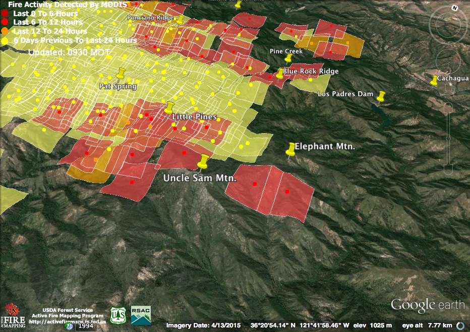
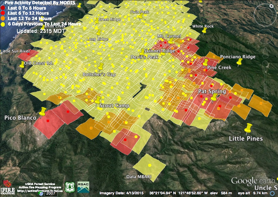
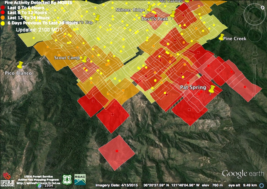
The biggest overnight expansion appears to have taken the fire past Pat Spring and on along the high ridges toward Little Pines. The fire also appears to be burning on Ponciano Ridge and advancing down the watersheds of Pine and Danish Creeks.
On the southern end, the fire is clearly well established along the North Fork of the Little Sur River and may be beginning to climb Launtz Ridge. It’s been working its way around the rocky slopes of Pico Blanco for more than 24 hours now.
This infrared map from 8:30 pm yesterday, indicates the fire had not quite reached Pat Springs at that time. It also shows what are likely burn out operations near the top of Serra Grade on the Old Coast Rd.
Although containment has not been raised from 15%, this morning’s Operations Map shows complete containment in Division A, above the Carmel Highlands, which is no doubt why evacuation orders have been lifted in that area. It also shows significant containment in Division B, above San Jose Creek. The only other section of contained line is above Garzas Creek in Rancho San Carlos.
This morning’s official numbers: 33,668 acres; 15% containment; 57 homes and 11 outbuildings burned; 3 homes and 2 outbuildings damaged; estimated final acreage 170,000; estimated final cost of suppression $80 million; current cost per day $6 million.
7-29-16 9:00 pm Maps & Notes
The fire spent the day continuing it’s southern and eastern expansion. The light red squares were detected around 1:00pm and the dark red squares around 2:30 pm.
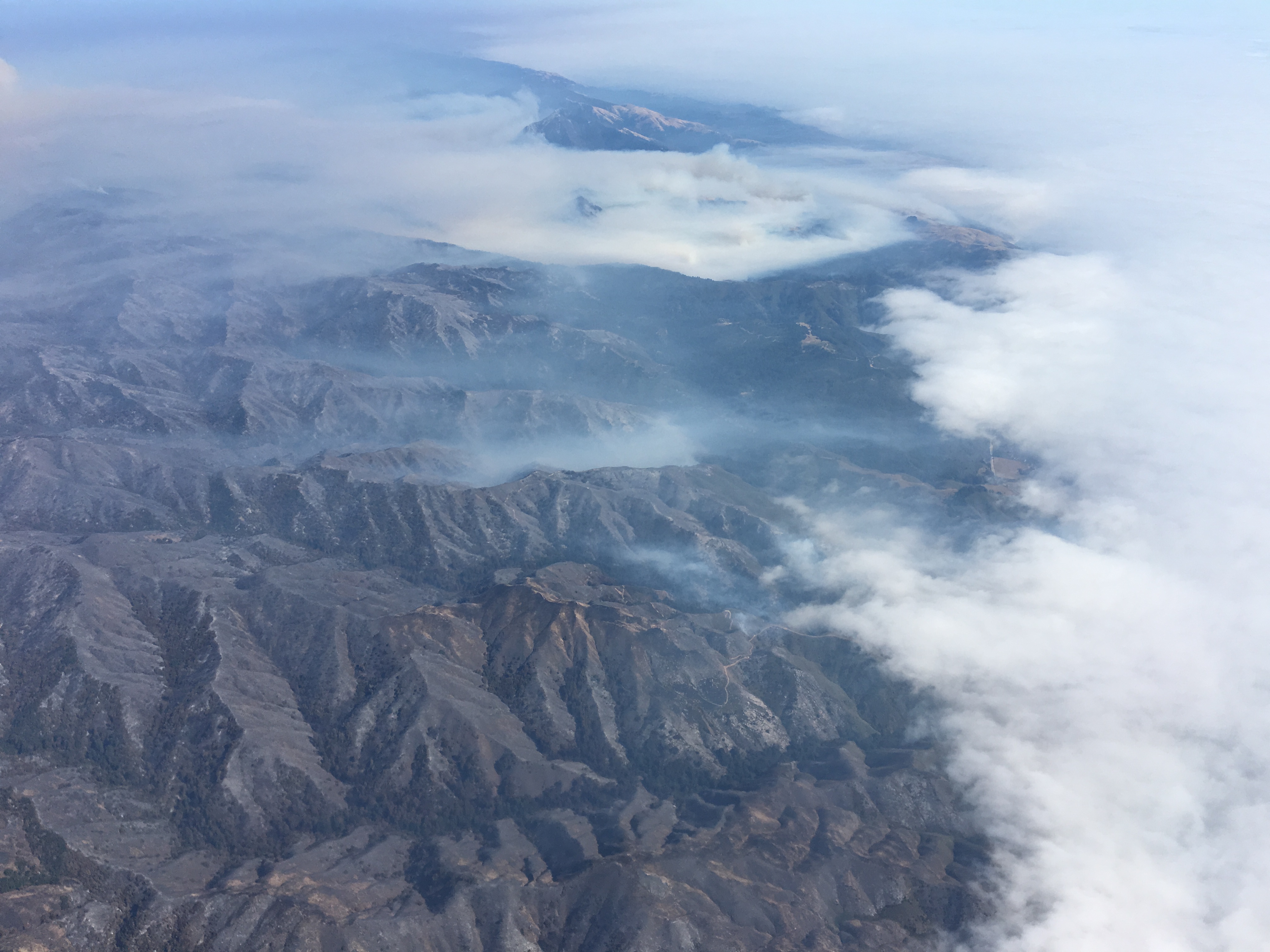
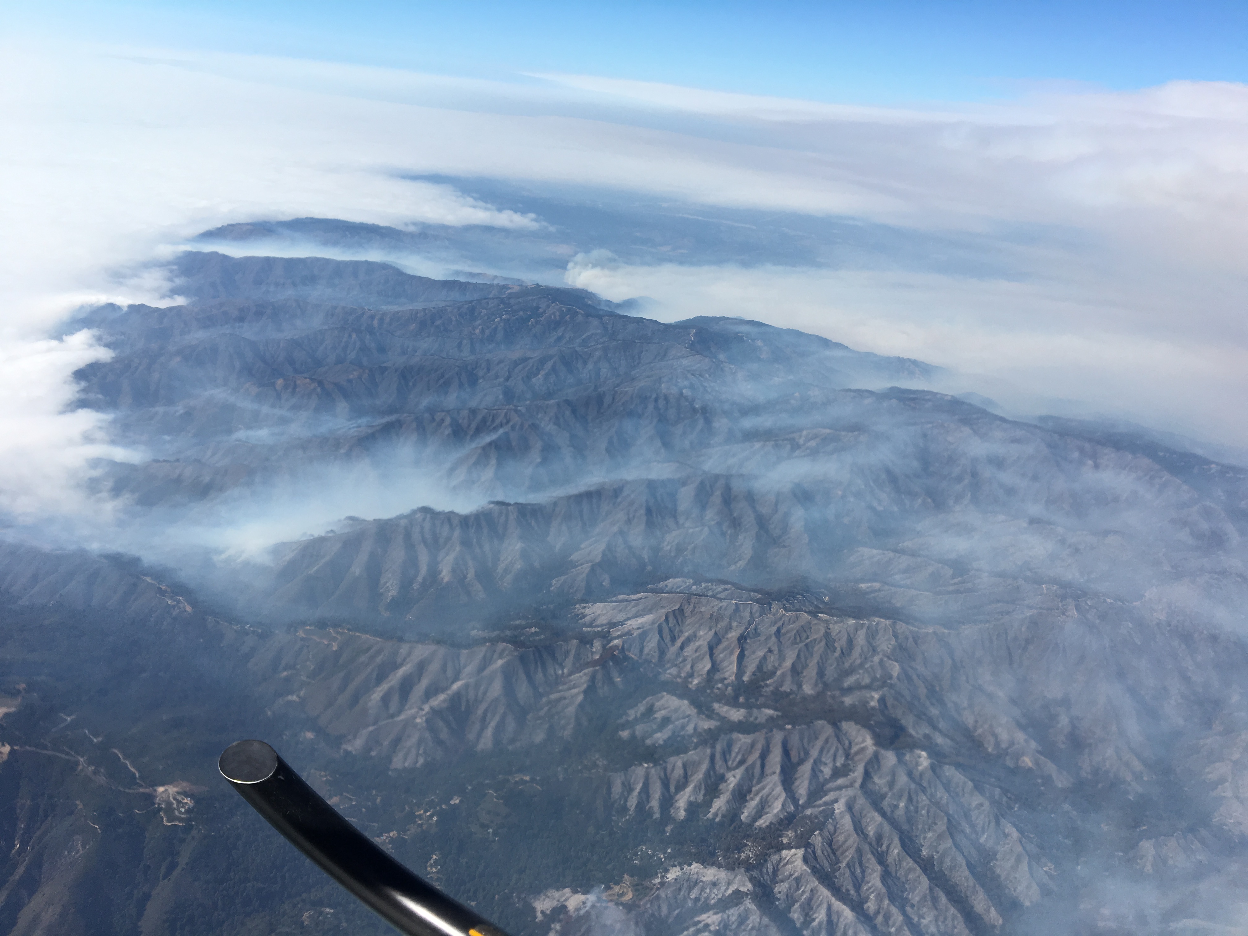
I had the opportunity to overfly the fire in a helicopter this afternoon (Thanks to Michael Troutman, Specialized Helicopters and others) and saw a large column rising from the location of these concentrated heat detections. Fire appeared to be raging across a broad area stretching from the headwaters of Pine Creek to the headwaters of Danish Creek and on into the Little Sur watershed. It may well have reached Pat Spring, but the smoke was too thick to be sure. Whether the outlying detection in the bottom of the North Fork Little Sur is in error or not hardly matters, as the fire will be there soon enough.
There were no heat detections in the Pico Blanco area today, but we saw fire slowly working its way up the rocky slopes, and some fire, although high on the mountain, had passed around to the east into the South Fork drainage (high on the slopes above Duveneck’s Hole).
The satellite suggests that the fire above White Rock (part of a planned burn out operation) continued to burn hot, but the smoke was far too thick to make out anything on the ground when we flew past.
Other things I noticed included:
Some fire still burning in lower Mal Paso Canyon;
No noticeable fire in Soberanes, Granite, or Doud Canyons;
A little fire still burning in lower Joshua Canyon;
Garrapata Canyon still burning here and there;
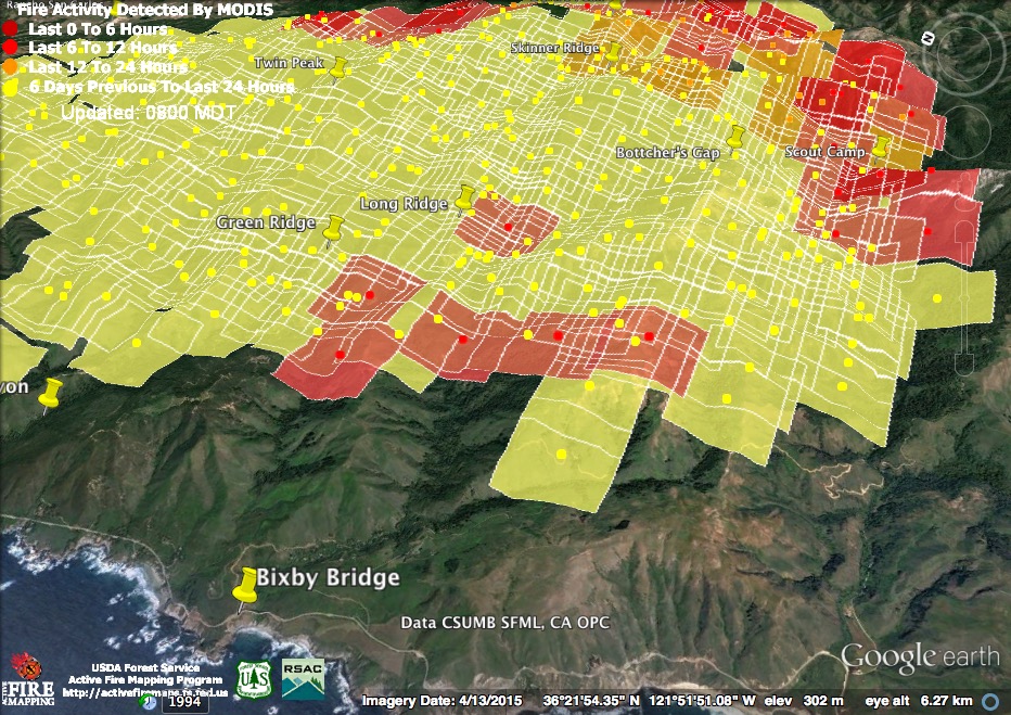
All but the lowest part of Green Ridge looking like a moonscape even from 9,000 ft.;
Heavy smoke south of Long Ridge and active fire burning on Long Ridge west of the Palo Colorado Rd.;
Active fire in Bixby Creek and on Mescal Ridge;
Portion of fire line marked as open above Seneca Creek on this morning’s maps now looks closed and fire in the area appears contained; and
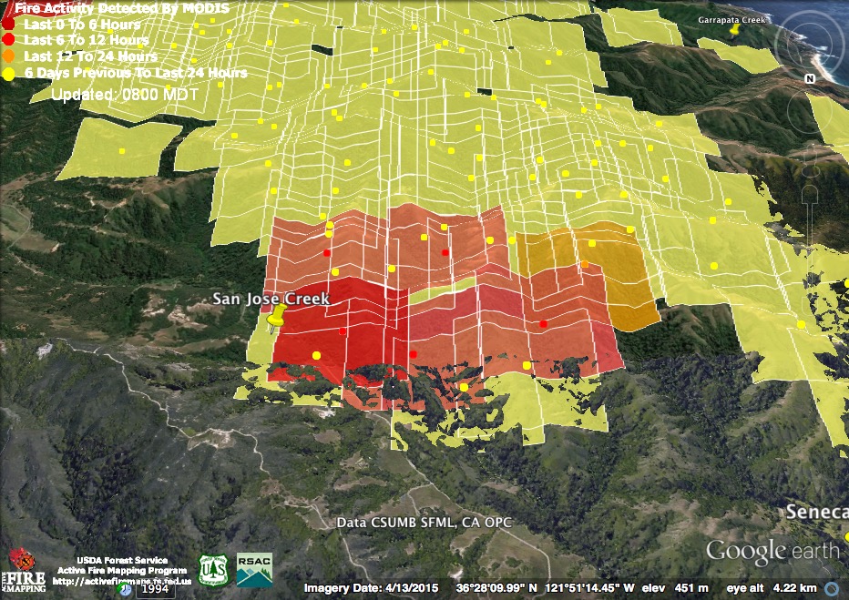
An apparent burn out operation underway on the east side of Palo Corona, near the Mitteldorf Preserve.
Here are some photos:
The coastal canyons looking south: One black, smoking ridge after another. The canyon in the foreground is Doud, followed by Joshua (where fog meets smoke), Wildcat (filled with smoke), Garrapata, etc.
Coastal canyons looking north: The still green bottom of Palo Colorado off the end of the skid.
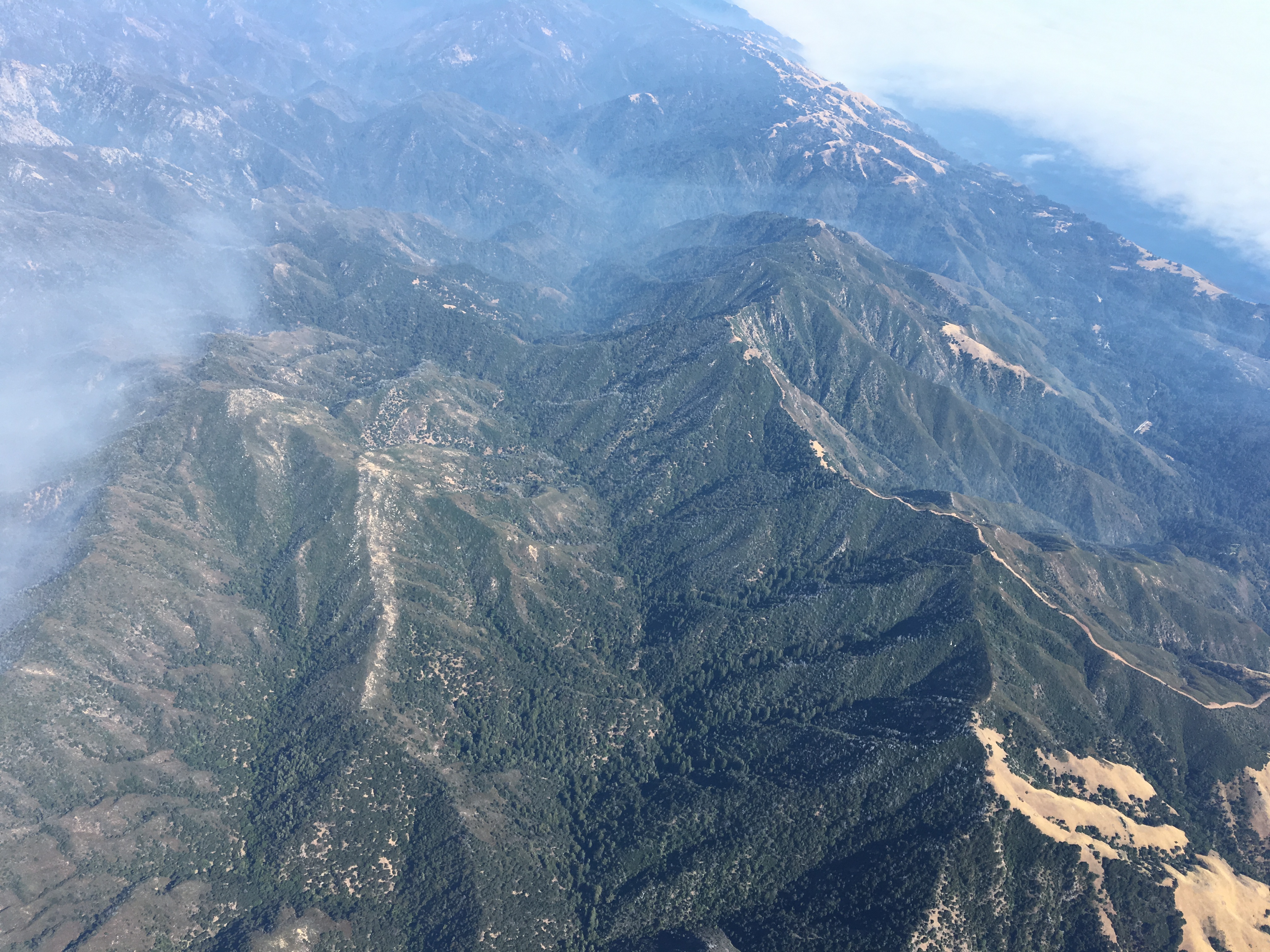
The upper South Fork Little Sur with the newly reopened dozer line over Post Summit visible to the right. This is the line intended to protect the Big Sur Valley.
A smokey day at the Ventana Double Cone.
That’s actually a pretty big fire burning near the Mitteldorf Preserve. But it’s dwarfed by the massive smoke cloud rising from the fire near Pat Spring. Viewed from above Ft. Ord.
Smoke above Highway 68.
This evening’s official numbers: 32,930 acres; 15% containment; 57 homes and 11 outbuildings burned; 3 homes and 2 outbuildings damaged.
7-29-16 8:00 am Maps & Notes
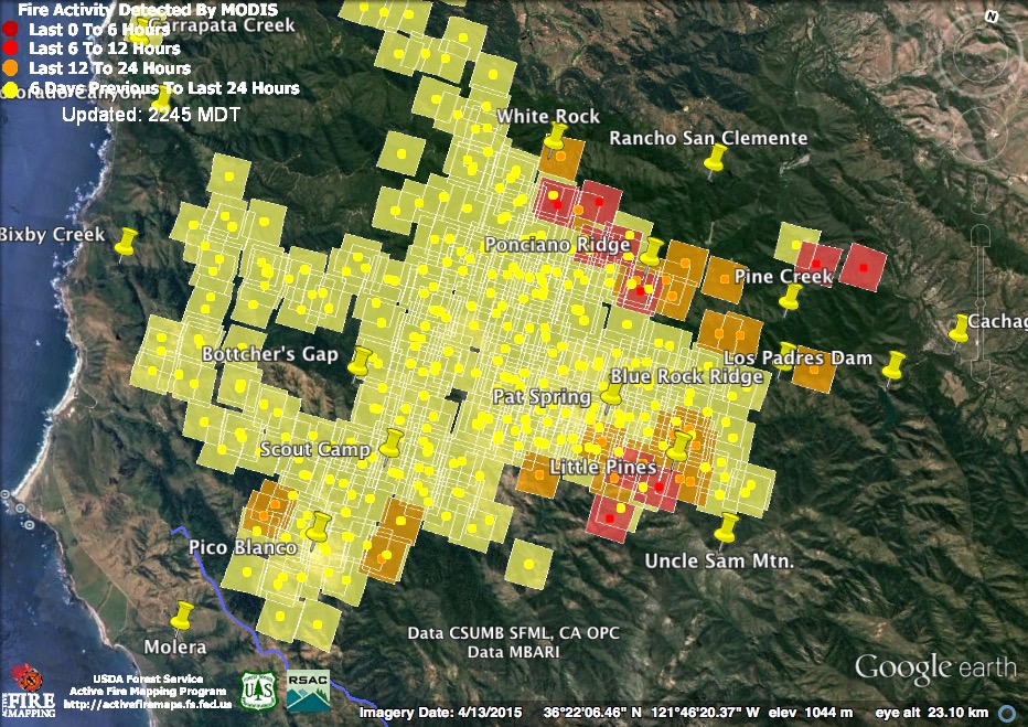
The fire stayed active overnight, with increased activity in the north and west and continued strong heat in the southwest quadrant. The light red squares represent detections from around 11:15 pm last night. The dark red squares were detected around 3:15 this morning.

Things had been pretty quiet around White Rock for the past few days, so hopefully the intense burning picked up by the satellite on its outskirts represents a planned burn out operation, rather than a new advance of the fire front.
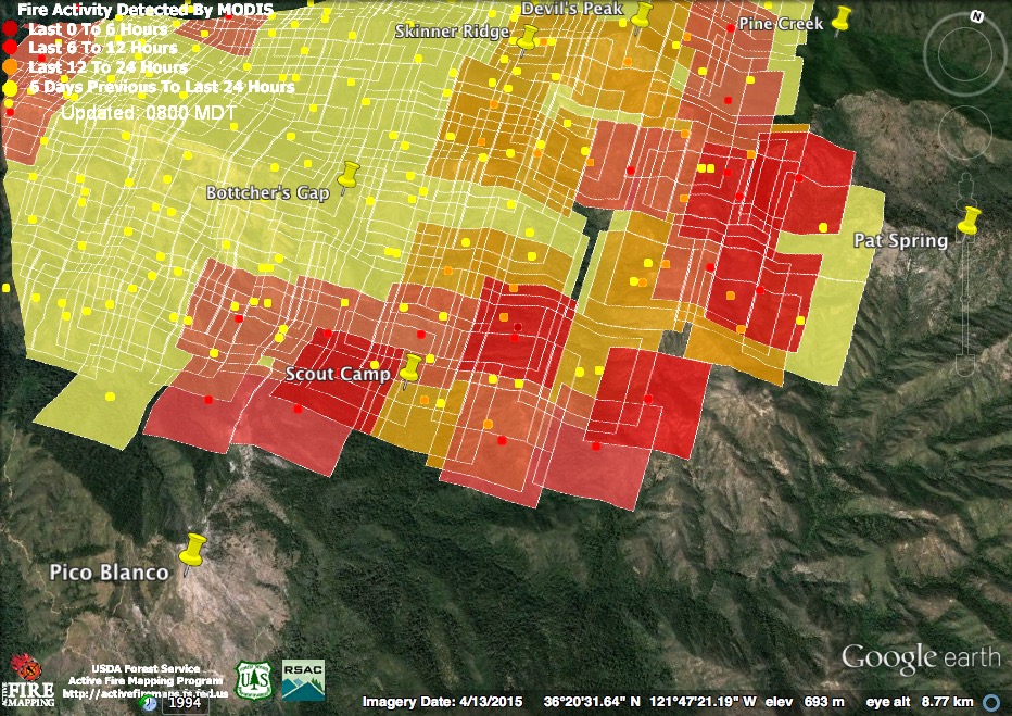
Active burning continued throughout the night from the White Rock area south across Pine Creek and into the Little Sur watershed. This fire front is well over the containment line on Skinner Ridge and, while it is obviously a low priority because it does not immediately threaten structures, it is unclear how, when, or where, it will eventually be contained.
Active burning was, once again, detected in the vicinity of the Scout Camp, but there is still no evidence of the fire crossing the North Fork of the Little Sur River.
The 11:30 pm satellite pass found active fire moving down Bixby and Rocky Creeks. This flare up had apparently calmed down before the 3:30 am pass. As can be seen from this morning’s Operations Map, though, there remains no containment along the fire’s entire western edge.
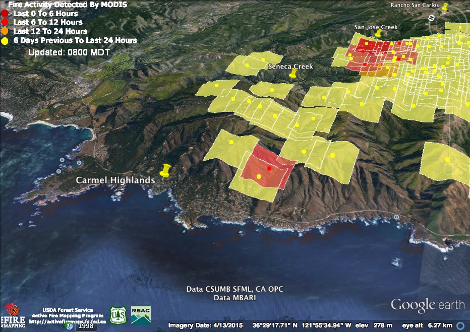
The 11:30 satellite pass also found renewed heat in Mal Paso Canyon. The good news for the Carmel Highlands, is that from Mal Paso north across the top of Corona Rd., Gibson Creek and Red Wolf Rd. the fire is now considered contained. Only a short segment of fire front facing Seneca Creek and the lower portion of Mal Paso Creek remain uncontained in the Highlands area.
At last night’s Carmel Valley fire meeting, fire officials stated that they expected the fire to continue actively burning around the Mitteldorf Preserve, near San Jose Creek, for some time to come. Overnight thermal imaging confirms that assessment. Extensive dozer lines are in place to prevent fire in this area from moving further into Rancho San Carlos or toward Carmel Valley.
This morning’s official numbers: 31,386 acres; 15% containment; 41 homes and 10 outbuildings burned; 2 “structures” and 2 outbuildings damaged.

Indeed, it is definitely unclear how, when, or where the southern end of the fire will be contained. It appears that any hope of keeping it north of South Fork the Little Sur River (the containment objective two days ago) has been abandoned. The objectives in today’s Incident Action Plan are:
• Keep the fire North of the Nacimiento-Fergusson Rd
• Keep the fire South of Huckleberry Hill
• Keep the fire West of Carmel Valley and Reliz Canyon
• Keep the fire East of Hwy 1in the North and the Coast Ridge Road in the South
An amazing summary. I have lived in high fire danger areas for the last 16 years, and am truly dismayed at the lack of information. The best I have seen recently was a local news helicopter broadcasting from 9K feet (out of the way) live video for an hour at a time at the Sand Fire. There is no way for people around a major fire to know what’s really happening on a fire beyond a 2x a day short briefing or a knock on the door. Twitter is filled with useless retweets. We need to figure something out. I’m thinking a live video heli feed, say 4x per day, mandatory, as part of the fire strategy, on every fire over something like 10K acres and less than 15% contained.
The Aircraft based IR scan from last night puts fire across the N. Fork Little Sur, and looks to be pretty high up Pico Blanco already.
https://mappingsupport.com/p/gmap4.php?t=t4&q=mymap,1mXFvUKWXGXO98rXRhZVhSjjur7Q
Please refrain from overstating what is trying to be accomplished. The unfortunate circumstances of this event, terrain, weather, etc have made this a challenge. Keith thank you for your very objective look at the overlays and what they may mean or not mean. This is not a criticism of anyone just wishing that we not jump to any conclusions not based on the circumstances.
Some of you may remember the Marble Cone Fire in 1977, the behavior of this fire seems similar to me. Effective point protection (defensible space) is the one thing that can be done, while we wait for and watch the approach.
on the map linked by Adam Clark above, are the yellow-ish areas burned but not actively burning? Forgive if I’m asking the obvious.
It’s all IR scan data from an airplane. Yellow is low heat, orange is intense heat, the red dots are localized spots.
Cool – thanks for clarifying.
It helps so much to have your narrative interpretation of the maps. Otherwise, for us amateurs, it’s hard to understand what’s changed from day to day. Thank you.
yes – thanks for the updates – here’s another map I’ve been following that was just updated today – http://yubanet.com/Fires/soberanes/
if you click on the link to the larger map – it’ll give you the satellite hybrid you can zoom in on. Not sure if totally accurate but very close to what’s described in the latest update here. Seems like this map is updated in advance of the Cal Fire page.
How tragic this fire is.
Thank you for all this great information. Like many, the names and locations of many the canyons, ridges, and such are unknown to me, although I can tell you about the area it started and ran through on the first couple of days. Is there a good map of Big Sur with these names and locations? If so it would be a help to all.
Thanks again
Bruce Merchant
The National Geographic map of Big Sur is a good one. The VWA worked NG to correct and verify accuracy of place names.
Thank you so much for this daily info. It has been my go-to source!
It is very foggy this morning in the upper Carmel Valley. The fog, and the cool air that caused it, probably slowed down the fire last night. Do you think the fog kept MODIS from finding as many hot spots as it would have seen had there been no fog?
Keith, today’s evening post has a typo, it is dated 8/3, and it’s still 8/2, fyi. Again, thanks for all your great mapping and reporting
Whoops… fixed.
Your maps and info are the best Xash ! Maybe we can walk the long lost San Clemente trail :
https://mappingsupport.com/p/gmap4.php?ll=36.427652,-121.722542&z=14&t=t4&markers=||36.414682,-121.72509436.414682,-121.725094&q=http://bigsurtrailmap.net/bigsur_trailmap.kml
Note the change in the legend on the IAP map for VDC. The line of division breaks is labeled as ridge / geographic feature. Looks like they’re counting on the rocky summit as a natural fire break??
On the IR maps at Little Pines there is a small symbol of a Bigfoot. Does anyone know what that means?
The last several heat maps have shown hits on the Rancho Cielo/ Galante side of Cachagua road. I’m tempted to disregard but the reading has been persistent. Anyone know if this is real?
I see only a corner of one of yesterday’s heat detection squares stretching across the Cachagua Rd. Remember that the squares represent the margin of error and that the actual point of detection could be anywhere in the square. The actual location of the heat in that square was undoubtedly up by the firebreak on the ridge between the Cachagua Rd. and the Carmel River (where firing operations were underway yesterday). There is no fire on the Galante/Rancho Cielo side of the road.
Makes sense. These maps become Rorschach tests when looked at for too long. Thanks much for your careful and useful work on all of this.