A Saturday with no obligations! I head off to the Ventana Wilderness with no particular destination in mind …

The parking lot for the trailhead at Los Padres Dam is gated for some reason these days, so it’s necessary to park down the hill at the Forest Service Station.

It’s a nice warm day, but there’s frost on the bridge over the spillway. A reminder that there can be some pretty big differences in temperature between day and night this time of year.

Rainfall for the season is still way below average, but the Los Padres Dam is full and spilling. The dam impounded 3,300 acre feet of water when it was built, in 1949, but has since lost more than half of that capacity to siltation. It doesn’t take much rain to fill it up.

California newts (Taricha torosa) love to go exploring when the ground is wet and, in the damp woods behind the reservoir, they’re wandering around everywhere. It takes a lot of care to avoid stepping on them.

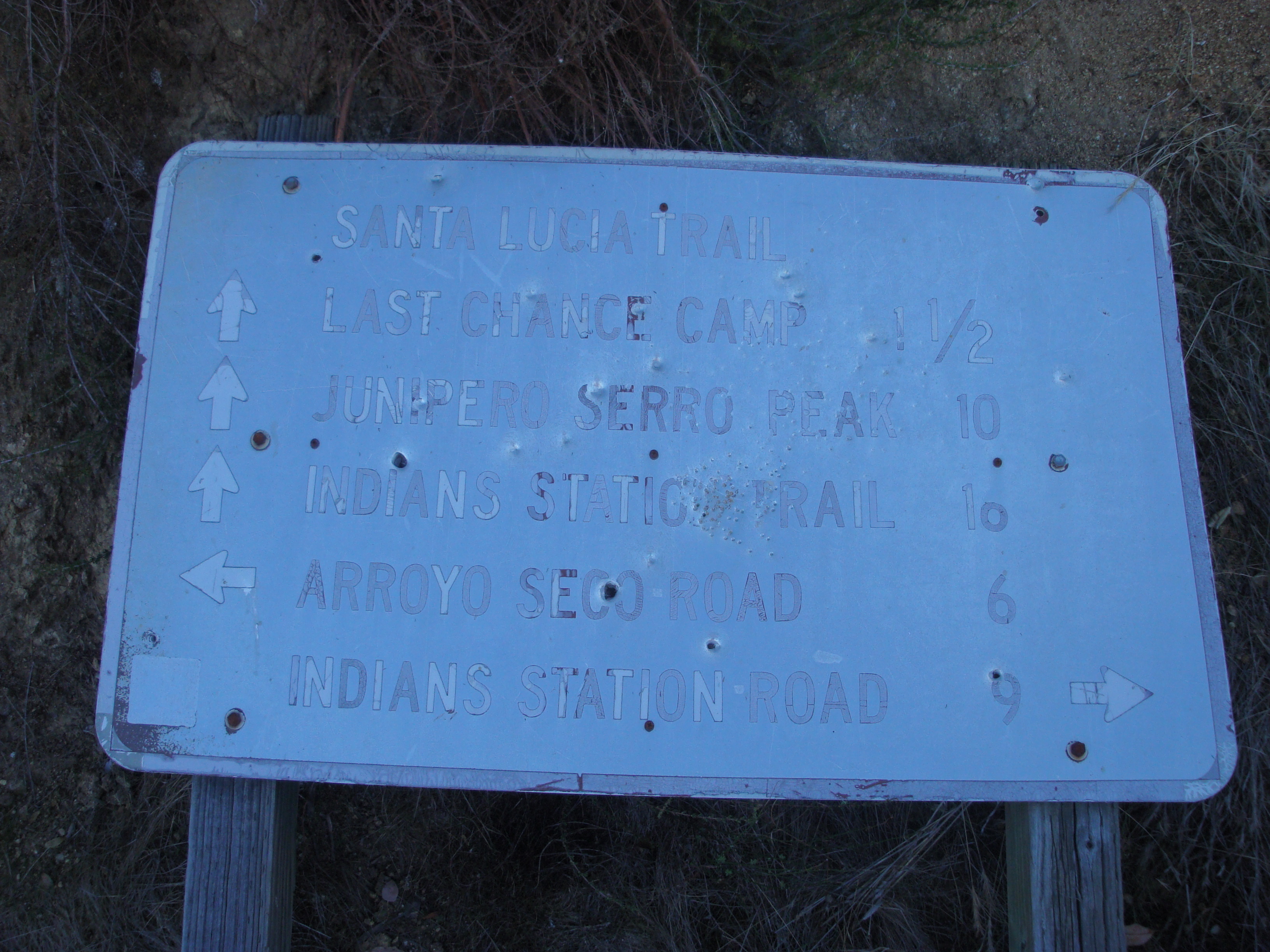
The junction of the Carmel River and Big Pines Trails. As in Arroyo Seco, the Forest Service remains a bit challenged when it comes to spelling. I choose uphill and take the Big Pines Trail.

The Big Pines Trail is in pretty decent shape as it switchbacks up to the top of the ridge. Poison oak is, as ever, a problem on this trail, but I decide to take advantage of my immunity and generate some good karma for myself by spending an hour or so cutting back the worst of it.

On top of the ridge, I zero the telephoto in on a band of cliffs a good ways up the Rattlesnake Creek drainage. This reminds me that Paul Danielson was asking last month on the Ventana Wilderness Alliance Forum whether anyone had recently tried following Rattlesnake Creek cross-country between its confluence with Danish Creek and Rattlesnake Camp. Should I maybe go take a closer look at those cliffs?

The burned post that marks the junction of the trail down to Danish Creek. The only thing that’s changed since the last time I was here is that the deer weed has gotten a lot taller.

The lower end of Blue Rock Ridge has always been a hot spot for ticks and today is no exception. As I descend to Danish Creek, which involves pushing through waist high deer weed and chamise, I have to stop and pick ticks off my legs every 100 yards or so. By the time I reach the bottom, I’ve removed dozens of them (black ones, red ones, grey ones – all sorts of ticks seem to congregate here).

Danish Creek Camp. The locals all pronounce the name duh-NISH, rather than DAY-nish … and that’s certainly the way I learned it, when I first followed the old-timers out here in the early 70’s. Donald Clark, in his Monterey County Place Names, theorizes that this is because the creek was once known as Denicio Creek, and he is, as usual, probably right.
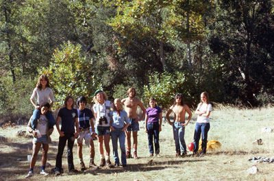
¡Flashback! … at Danish Creek Camp with some friends in 1974. Ah … memories!

The confluence of Rattlesnake and Danish Creeks isn’t far upstream from the camp. Remarkably, the minute I step across the stream there are no more tick problems. It always seems to be like that here.

A small swarm of lady bird beetles near the confluence. Lady bug swarms are common in winter along Santa Lucia streams and sometimes involve thousands, if not tens of thousands of lady bugs.

With open flats along the edges of the stream, the going proves to be much easier than expected along the lower stretches of Rattlesnake Creek.

Black Elfin Saddles (Helvella lacunosa) growing near the stream. Sometimes mistaken for morels, they are edible but, in my opinion anyway, not particularly good.

The canyon’s unusually flat and open bottom appears to have been created at some time in the past by massive debris flows filling in a deeper streambed. Under a thin layer of soil it’s nothing but a jumble of rocks.

Milk maids, or toothwort if you prefer (Cardamine californica).

Well, that acorn certainly landed in a good spot.

Recently deceased Western Gray Squirrel (Sciurus griseus). It’s been tough times for the Gray Squirrels in Monterey County in recent years as introduced Eastern Fox Squirrels have been taking over their territory and pushing them aside (not to mention raiding our plum tree, which the Gray Squirrels, who prefer pine nuts, are nice enough not to do). Out in the mountains, I’m glad to say, the Gray Squirrels still seem to rule.

The easy travel ends.

The canyon walls close in and the stream is flowing over bedrock.

Narrower and steeper. This is what off-trail travel in the Ventana Wilderness is supposed to look like.

Some sort of Hygrocybe, probably H. flavescens or persistens, growing in the spray from the falls.

The going along the creek is getting pretty slow, but a granite spur – a continuation of the cliffs seen earlier – squeezes down into the gorge and offers a steep, but potentially passable route to the ridge-top and the Rattlesnake Trail.

Another fall and plunge pool comes into view as the climb begins.

By Santa Lucia standards, the rock on this spur is remarkably solid. Can’t complain!

Rattlesnake Creek continues climbing steeply toward Rattlesnake Camp. How many more falls between here and there? The answer will have to wait for another day.

The Sierra de Salinas appears and it’s time to stop for some refreshment before tackling the face to the left. A few easy moves up the dirty crack, then a swing around the corner into the dihedral with the big green deer weed bush and I’m home free. Well, it’s a plan anyway.

And it all works out. I reach the top of the spur. The Rattlesnake Trail should be somewhere behind those trees on the top of the ridge to the left.

More memories … Back in the ’70’s, I went on an off-trail day-hike with some old-timers who wanted to see Johnson Camp. After we found it, we crossed the saddle on the skyline and descended to Rattlesnake Creek and on home. Good times …

The brush that’s regrown since the fire is still pretty soft, so making headway isn’t nearly as difficult as it looks. Ridgetop getting closer!

Back in civilization! The Rattlesnake Trail, complete with plastic ribbon.

I celebrate too soon. The Rattlesnake Trail proves to be tougher going than the off-trail route I’ve just taken. I’m still pushing through the brush, but now I’m having to climb through awkward deadfalls too.

Until the trail reaches the gently sloping Black Oak and Madroño groves that descend to Danish Creek, that is. From there on down, it’s a cake walk.

A coral mushroom on the forest floor. Probably Ramaria rasilispora.

I’ve seen a lot of lion scat in the woods over the years, but nothing remotely approaching this in size. I should have put something down there for scale. This is clearly the home of one really, really big kitty cat.

The trail reaches Danish Creek near the site of the Nason’s old cabin. The cabin got smashed by a falling tree during a storm in the ’90’s and it looks like the fire finished it off.

Will do …

In hopes of encountering fewer ticks, I take the old road from the cabin over the ridge.

It doesn’t work. I had to pick off dozens of ticks on the way down the trail. On the way up the road I pick off hundreds. Saw two deer half way up. Don’t know how they stand it there.

Pacific houndstongue (Cynoglossum grande).

Evening light at Los Padres Dam.

Mighty fine tour X-man!
Amazing trail walking, photos and narration, as usual. Thanks.
Beautiful article. Thanks so much. What a backyard we have here!!
Great tour. Thanks.
Thanks for giving some views of what lies up lower Rattlesnake Creek – I want to get up to that waterfall someday. BTW I found and took a photo of scat from what is likely the same large cat, found near the base of Rattlesnake Creek Trail (with my glove and pole to give a sense of scale).
BTW, the ‘duh-nish’ is because the creek was originally named after a homesteader named D’Nish. It used to show up that way on old maps, but some cartographer in the 1930’s or so misspelled it. That is the story according to my grandfather, who owned a ranch just below the Los Padres damsite in the Cachagua at the time before the dam was built. They later moved to a ranch directly on the other side of the ridge to the north in the Tullarcitos. I spent many trips going up that drainage to Pine Valley, or across Pine Ridge, even down the Big Sur to Pfeiffer Grove. (I’ve read and re-read your photo of the trail signs and do not see what the challenged spelling would be?)
I’ve seen Denicio Creek on old maps, but not D’Nish. The trail sign misspells Bottchers (only one T).